
Have you ever wondered how engineers map out hillsides before building roads, or how experts predict landslides in mountainous regions? The answer often lies in a powerful technology called LiDAR. From scanning forests from the sky to guiding self-driving cars on highways, LiDAR is quickly becoming an essential tool across a wide range of industries.
In the world of geotechnical engineering, where every slope, contour, and crack in the earth matters, LiDAR offers something traditional tools can’t: fast, accurate, and high-resolution data of the terrain—captured from a distance. Whether it’s for planning hillside developments, analyzing slope stability, or designing drainage systems in flood-prone areas, LiDAR is revolutionizing how engineers understand the ground they build on.
So, what is LiDAR exactly? And why is it becoming a go-to technology in Malaysia and around the world for geotechnical work? This article will walk you through everything you need to know, from the basics to real-world applications.
What is LiDAR?
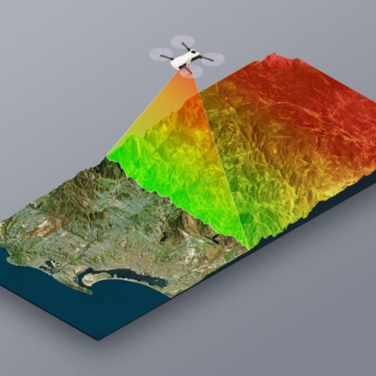
LiDAR stands for Light Detection and Ranging. It’s a remote sensing technology that uses laser light to measure the distance between a sensor and the surface of the Earth.
A LiDAR system sends out thousands of laser pulses per second, and when these pulses hit an object like the ground, vegetation, or buildings, they bounce back to the sensor. By measuring how long it takes for the light to return, LiDAR calculates precise distance and elevation data.
The result is a massive collection of 3D data points called a point cloud, which can be processed into detailed terrain maps, elevation models, or 3D surface models.
Why is LiDAR Important in Geotechnical Engineering?
In the geotechnical industry, understanding the surface condition of the ground is critical for safe and cost-effective construction. Here’s how LiDAR directly supports core areas of geotechnical analysis:
1. Slope Stability Analysis
LiDAR can detect subtle changes in terrain over time. Engineers use high-resolution elevation models to identify slope angles, surface cracks, bulges, or deformations, all of which can indicate unstable ground. With LiDAR, you can simulate slope failure scenarios and assess how rain, construction, or excavation might affect slope behavior.
2. Landslide Risk Assessment
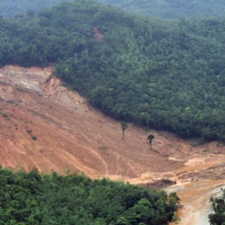
Malaysia is no stranger to landslides, especially in hilly areas like Bukit Antarabangsa or Cameron Highlands. After heavy rainfall, the risk increases. LiDAR helps identify potential landslide zones by analyzing slope steepness, vegetation cover, and surface water flow. By combining LiDAR data with rainfall history and soil investigation, engineers can predict which areas are most at risk.
3. Terrain and Topographic Modeling
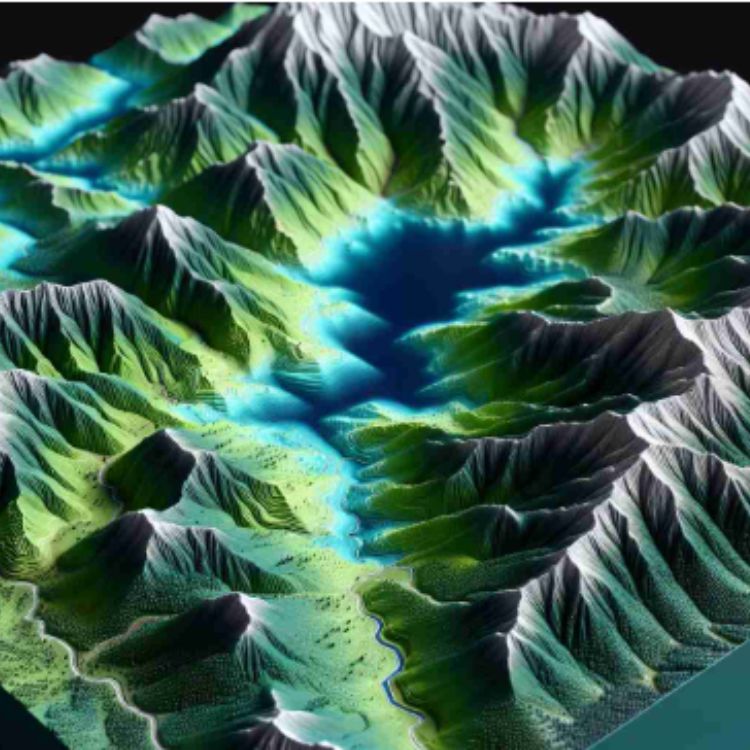
LiDAR is perfect for generating Digital Elevation Models (DEM) and Digital Terrain Models (DTM). These models are crucial for road alignment, tunnel portals, embankments, and any infrastructure project where ground shape affects design. The accuracy allows geotechnical engineers to assess the natural contours before any digging begins.
4. Drainage and Surface Water Flow Analysis
Surface water can destabilize slopes and foundations. With LiDAR-derived models, engineers can simulate how rainwater will flow, pond, or erode soil. Proper drainage design begins with accurate topography, and LiDAR provides that in rich detail even capturing minor depressions or ridges that affect runoff.
5. Earthwork Volume Estimation
Need to calculate how much soil to cut or fill for a highway, slope remediation, or retaining wall? LiDAR gives you precise data to perform cut-and-fill analysis. This helps optimize material usage, reduce cost, and avoid over- or under-excavation.
Types of LiDAR Used in Geotechnical Work

There are two main types of LiDAR that are particularly relevant in geotechnical engineering:
1. Terrestrial LiDAR
This system is mounted on a tripod or vehicle on the ground, scanning the nearby terrain or structures. Terrestrial LiDAR is ideal for detailed analysis of slopes, rock faces, retaining walls, and construction sites. It captures high-resolution data at a close range, which is excellent for engineering design and deformation monitoring.
For example, if engineers want to monitor a cut slope along the Karak Highway, terrestrial LiDAR can scan the slope every month to detect any subtle ground movements or rockfall risks.
2. Airborne LiDAR (or Drone LiDAR)
Mounted on aircraft or UAVs (drones), this LiDAR type scans large areas quickly, even over dense vegetation or difficult terrain. Airborne LiDAR is especially useful for initial site investigations, landslide mapping, and large-scale topographic modeling.
In hilly Malaysian regions like Kundasang, Sabah, drone-based LiDAR helps engineers map landslide-prone areas without risking the safety of survey teams.
How is LiDAR data processed and analyzed?
Processing and analyzing LiDAR data is a multi-step workflow that transforms raw laser pulse information into accurate, usable insights like maps, 3D models, or terrain analysis. While the technology behind it is advanced, the overall process can be explained clearly in six key stages:
1. Data Acquisition
It all starts with collecting the raw LiDAR data using a LiDAR sensor. This could be mounted on a drone, airplane, vehicle, or tripod (for terrestrial scanning). As the sensor emits laser pulses, it records the return time and intensity of each pulse. Along with the laser data, the system simultaneously records GPS coordinates (to track location) and IMU data (to track orientation and movement).
This step results in a huge amount of raw data, often millions of 3D points per second, known as a point cloud.
2. Pre-processing and Georeferencing
Before the data can be used, it must be cleaned and georeferenced:
- Georeferencing aligns the LiDAR points with real-world coordinates using GPS and IMU data.
- Noise filtering removes stray or inaccurate points caused by interference (e.g., birds, wires, or weather conditions).
- Trajectory correction ensures the data accurately reflects the flight or scanning path, correcting for sensor drift or GPS errors.
At the end of this stage, the LiDAR point cloud is clean, accurate, and tied to a specific location on Earth.
3. Classification of Point Cloud
Next, the LiDAR point cloud is classified, which means labeling each point based on what it hit such as ground, vegetation, buildings, water, or powerlines. This is usually done using algorithms that analyze the height, shape, and density of nearby points.
For example:
- Points close to the ground with smooth elevation changes may be classified as bare earth.
- Higher, irregular points might be labeled as trees or structures.
This classification is essential for creating specific outputs like bare-earth terrain models (useful in geotechnical engineering) or canopy height models (used in forestry).
4. Generating Digital Models
Once classified, the data can be used to generate digital models:
- Digital Elevation Model (DEM): Represents the bare ground surface, excluding vegetation and buildings.
- Digital Surface Model (DSM): Includes all features like trees and buildings.
- Canopy Height Model (CHM): Created by subtracting the DEM from the DSM, showing vegetation height.
These models are created using interpolation methods that fill in gaps between LiDAR points, turning the point cloud into a continuous surface or grid.
5. Visualization and Analysis
With digital models in hand, users can now visualize and analyze the terrain or structures. Depending on the application, this could include:
- Slope and aspect analysis for landslide risk assessment (geotechnical engineering)
- Volume calculations for cut-and-fill operations in construction
- Flood modeling using elevation data
- Change detection by comparing LiDAR data from different time periods
- 3D visualization for urban planning or archaeology
Specialized software like LAStools, ArcGIS, Global Mapper, CloudCompare, or Terrasolid helps visualize, edit, and analyze these datasets.
6. Exporting and Sharing
Finally, processed LiDAR data can be exported into various formats such as LAS (LiDAR point cloud format), GeoTIFF (for elevation models), or CAD formats (for construction projects). These files are then used by engineers, scientists, or developers in their respective software environments.
How Does LiDAR Compare to Traditional Surveying Methods?
LiDAR is often seen as a game-changer in spatial data collection but how does it actually stack up against traditional surveying methods like total station, theodolite, GPS surveying, or photogrammetry?
Let’s break down the comparison based on key factors such as accuracy, speed, efficiency, coverage, cost, and accessibility
Accuracy
Both LiDAR and traditional surveying methods can deliver high accuracy, but the type of accuracy differs.
Traditional surveying with total stations or GPS offers precise point-by-point accuracy, often down to millimeters, making it ideal for small-scale, high-detail projects like construction layout or boundary determination.
LiDAR, on the other hand, provides high relative accuracy over large areas, especially when combined with GPS and IMU data. While individual LiDAR points might be accurate to a few centimeters, the strength lies in the sheer volume and density of points, creating detailed 3D representations of terrain or structures.
In short:
Traditional surveying = pinpoint accuracy at specific spots
LiDAR = high-density accuracy across large areas
Speed and Efficiency
This is where LiDAR really shines. Traditional surveying involves setting up instruments, taking manual measurements, and moving around the site, time-consuming and labor-intensive, especially in difficult terrain.
LiDAR, particularly airborne LiDAR, can scan hundreds of square kilometers in a few hours, collecting millions of data points in that time. For example, a drone-mounted LiDAR system can map a forest, cliff face, or construction site in a fraction of the time it would take a ground survey crew.
This makes LiDAR incredibly efficient for large or hard-to-reach areas like steep slopes, forests, disaster zones, or urban areas with restricted access.
Data Density and Detail
Traditional survey methods typically collect discrete points every few meters or at key features. The result is a sparse dataset, which can miss subtle changes in elevation or small objects between points.
LiDAR collects thousands of points per square meter, capturing a continuous and detailed model of the environment. This level of detail allows for advanced analysis like slope stability, erosion modeling, canopy structure, or change detection over time.
In applications like geotechnical engineering, this detailed terrain data is crucial for accurate modeling and risk assessment.
Coverage and Accessibility
Traditional surveys are limited by physical access. Areas with thick vegetation, steep terrain, or safety hazards are difficult and dangerous to survey manually.
LiDAR, especially from drones or aircraft can easily scan areas that are otherwise inaccessible. Its ability to penetrate vegetation (especially using near-infrared lasers) also allows it to “see” the ground beneath forest canopies, which is something photogrammetry and human surveyors can’t do well.
This makes LiDAR especially useful in remote sensing, environmental studies, disaster response, and archaeology.
Cost
Here’s where the comparison gets nuanced.
- Traditional surveying is generally cheaper for small sites, especially when high-precision at specific points is needed.
- LiDAR systems, especially airborne or high-end terrestrial units, come with higher upfront costs, including sensors, GPS/IMU systems, and software. However, the cost per square kilometer drops dramatically for large or complex sites because of the time and labor saved.
In other words, LiDAR may seem expensive at first, but it pays off in productivity for large-scale projects.
Skill and Data Processing
Traditional surveying requires trained personnel but produces simpler datasets that are easier to manage.
LiDAR requires specialized skills for data processing, filtering, classification, and analysis. The raw data, often in the form of massive point clouds, must be processed using GIS or point cloud software (like ArcGIS, LAStools, or CloudCompare), which adds a layer of complexity.
However, the quality and depth of insights that can be extracted from LiDAR data far exceed what traditional methods can offer on their own.
LiDAR Applications in Malaysia
Malaysia’s unique terrain, ranging from mountainous regions in Sabah to flood-prone lowlands in Kelantan makes terrain understanding and land monitoring critical. LiDAR is increasingly being used across various sectors in the country, especially in geotechnical engineering, environmental monitoring, urban planning, and disaster risk management.
Below are several key applications of LiDAR in Malaysia, with specific relevance to real geotechnical scenarios and local challenges.
1. Landslide Mapping and Slope Stability Monitoring
Malaysia’s tropical climate leads to frequent rainfall, which contributes to landslides and slope failures, especially in hilly areas like Bukit Antarabangsa, Genting Highlands, Fraser’s Hill, and Cameron Highlands.
LiDAR helps by:
- Creating high-resolution Digital Elevation Models (DEMs) to detect dangerous slope gradients.
- Allowing comparison of terrain models over time to spot early signs of ground movement.
- Supporting authorities like Jabatan Kerja Raya (JKR) and Minerals and Geoscience Department (JMG) in hazard zoning and emergency response.
After a deadly landslide in Bukit Kukus, Penang in 2018, drone-mounted LiDAR was used to scan the affected slope and assess the failure geometry. The data helped with forensic investigation and also guided future slope reinforcement plans.
2. Flood Risk Mapping and Drainage Design

Low-lying states like Kelantan, Terengganu, and Johor often suffer from seasonal flooding. Traditional flood modeling using manual surveys is often slow and outdated.
With LiDAR:
- Engineers can build detailed floodplain models and simulate how water will flow and accumulate after rainfall.
- Urban planners use this data to design better drainage systems, retention ponds, and levees.
3. Infrastructure Planning and Earthwork Estimation
During the East Coast Rail Link (ECRL) project, LiDAR was used for route planning through hilly regions in Pahang and Terengganu. This helped engineers assess slope risks and reduce costly rework due to unexpected terrain conditions.
When constructing highways, railways (e.g. ECRL or MRT3), or housing projects, understanding the terrain is crucial.
LiDAR supports geotechnical work by:
- Quickly generating cut-and-fill calculations.
- Identifying unstable slopes along planned alignments.
- Mapping ground surfaces under vegetation, which is useful in forested areas.
4. Urban Expansion and Terrain Analysis

In rapidly urbanizing areas like Klang Valley, LiDAR data is used to:
- Map ground elevation and contours before development begins.
- Assist town planners in avoiding construction on unstable or flood-prone land.
- Optimize the placement of roads, drainage systems, and utilities.
The Iskandar Malaysia Development Region used LiDAR to survey thousands of hectares of mixed terrain. The data helped ensure sustainable land use and reduce the environmental impact of rapid construction.
5. Environmental and Forest Monitoring
Beyond urban and infrastructure applications, LiDAR is helping protect Malaysia’s sensitive environments.
For instance:
- It maps canopy heights, tree density, and biomass for forest management.
- It detects illegal logging and land encroachment in protected reserves.
- It helps identify erosion-prone riverbanks and slopes that threaten biodiversity.
FRIM (Forest Research Institute Malaysia) and various state forestry departments use LiDAR data to monitor forest health and plan reforestation programs, especially in degraded areas of Sabah and Sarawak.
6. Disaster Response and Recovery

When disasters like landslides or floods occur, rapid terrain mapping is essential for response teams.
After the 2022 Batang Kali landslide, LiDAR scans were used by engineers and first responders to assess the stability of nearby slopes and ensure no secondary failures would occur during rescue efforts.
LiDAR helps emergency teams by:
- Mapping the damage quickly using drone-mounted LiDAR.
- Assessing which slopes are still unstable post-disaster.
- Aiding in safe access route planning and debris flow modeling.
Used of Lidar by Government Agency
In the past, LiDAR was often seen as a high-cost, high-tech tool reserved for large engineering firms or international projects. But today, in Malaysia, LiDAR is being actively embraced by government departments and public agencies as a strategic tool to tackle challenges in land development, hazard mitigation, and infrastructure planning. Here’s how key agencies are using LiDAR in their operations:
Jabatan Ukur dan Pemetaan Malaysia (JUPEM)
JUPEM, under the Ministry of Defence, is the official authority for mapping and geospatial data in Malaysia. It has played a leading role in adopting LiDAR for:
- High-resolution national topographic surveys, especially in forested and mountainous areas that are hard to survey with traditional methods.
- Supporting the 3D Malaysia initiative, which aims to create nationwide 3D city models for planning, smart city development, and disaster management.
- Producing Digital Terrain Models (DTM) and Digital Surface Models (DSM) at high accuracy, which are foundational datasets for use by other agencies and private consultants.
JUPEM has used airborne LiDAR extensively in Sabah and Sarawak to overcome the challenges of mapping vast, rugged, and jungle-covered terrains where traditional ground surveys are impractical.
Jabatan Pengairan dan Saliran (JPS)
JPS, or the Department of Irrigation and Drainage, uses LiDAR data as part of its Integrated River Basin Management (IRBM) programs and flood mitigation planning.
Key applications include:
- Modeling flood-prone areas using precise elevation data to simulate water movement during heavy rainfall.
- Planning and optimizing urban drainage systems based on actual surface runoff patterns.
- Identifying and prioritizing critical areas for flood control structures like retention ponds, diversion channels, and embankments.
In areas like Klang and Shah Alam, JPS has partnered with consultants using LiDAR data to refine flood hazard maps, leading to more targeted infrastructure improvements under the Smart Selangor initiative.
Jabatan Mineral dan Geosains Malaysia (JMG)
JMG, which is responsible for geological and geoscientific studies, has incorporated LiDAR into its national slope inventory and landslide hazard assessment programs.
LiDAR helps JMG:
- Map and monitor unstable slopes, particularly in high-risk areas like Hulu Selangor, Cameron Highlands, and Baling.
- Generate detailed slope profiles for failure zone identification and early warning system development.
- Create landslide susceptibility maps by integrating LiDAR with rainfall, soil, and rock data.
In 2021, JMG conducted LiDAR surveys in several slope-prone areas in Sabah to assess the impact of heavy monsoon rainfall on hillslope stability, helping local councils plan reinforcement and drainage works.
Jabatan Kerja Raya (JKR)
As Malaysia’s national public works agency, JKR plays a crucial role in road construction, slope maintenance, and public infrastructure development. LiDAR has become a valuable tool in their engineering workflow, especially for:
- Designing road alignments through hilly or forested terrain, like in the Pan Borneo Highway or upgrading trunk roads in Pahang and Perak.
- Estimating cut-and-fill volumes for highway construction with high precision—reducing cost overruns and material wastage.
- Performing slope audits and inspections, particularly in areas like the East-West Highway (Gerik–Jeli) or Karak Highway, where landslides pose frequent risks.
- Supporting asset inventory management using 3D scanning of existing infrastructure.
JKR Terengganu used drone-based LiDAR to reassess several older hill roads after multiple slope failures, and re-prioritized slope strengthening measures using the high-resolution terrain data.
LiDAR is no longer just a high-tech buzzword, it’s a practical, powerful tool that’s transforming how we approach land, slope, and infrastructure projects in Malaysia.
With its ability to deliver fast, accurate terrain data, LiDAR is now an essential part of geotechnical work, from site investigations to disaster prevention. As more government agencies and engineers adopt this technology, the future of smarter, safer development is already taking shape.

