
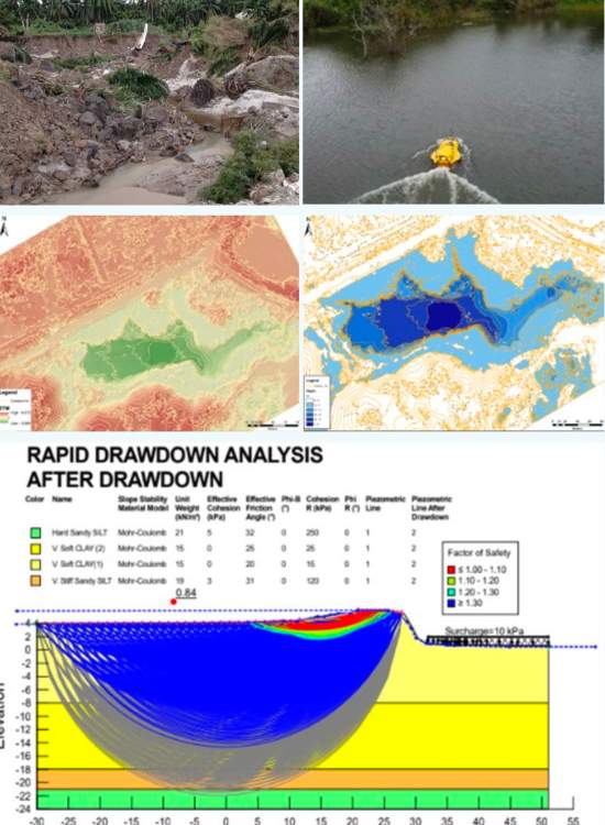
In December 2022, a combined flood and landslide event occurred near Kg Lombong, affecting a portion of the TULIP pipeline right-of-way, suspected to have been triggered by heavy rainfall. Geotechnica Sdn Bhd was engaged to assess and identify the possible root cause of the failure for Petronas Gas Berhad and Axianergy (M) Sdn Bhd.
CLIENT
YEAR
Petronas Gas Berhad / Axianergy (M) Sdn Bhd
2022
Root-cause investigation of a combined flood and landslide event affecting the TULIP pipeline right-of-way near Kg Lombong.
A combined flood and landslide event occurred in December 2022, suspected to have been triggered by heavy rainfall, affecting a portion of the pipeline corridor.
A multidisciplinary assessment spanning geology, geotechnics, geospatial analysis and hydrology was needed, requiring both on-ground and underwater-bed topographic data.
Multidisciplinary Field Assessment
Geology, geotechnics, geospatial analysis and hydrology combined to investigate the failure event.
USV/UAV Survey
USV/UAV Survey Unmanned surface and aerial vehicles deployed to capture both on-ground and underwater-bed topography.
Integrated Topographic Modelling
On-ground and underwater-bed data combined into a single comprehensive model of the affected corridor.
A comprehensive on-ground and underwater-bed topographic model was generated for the affected corridor.
The multidisciplinary assessment identified site conditions consistent with a rainfall-triggered flood and landslide event impacting the right-of-way.
The comprehensive on-ground and underwater-bed topographic model gives Petronas Gas Berhad and Axianergy a clear picture of the corridor's condition following the incident, supporting root-cause determination and remedial planning for the affected right-of-way.
Navigation Panel
Contact Us
Geotechnica Sdn Bhd
Wisma ESO,
No. 3-2,
Jalan Suria Puchong 4,
Puchong Gateway Square,
Pusat Perniagaan Suria Puchong,
47110 Puchong, Selangor.
Tel: 03-5569 7765
Email: admin@geotechnica.com.my
All rights reserved. Copyright © 2026 Geotechnica Sdn Bhd (1378487-P)