
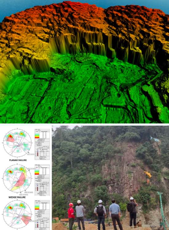
Rock masses at the PJU8, Bukit Lanjan site are subject to primary and secondary geological structures that act as planes of weakness. Geotechnica Sdn Bhd was engaged by Vestland and Max Engineering Sdn Bhd to map these structures and assess rock slope failure risk ahead of proposed development.
CLIENT
YEAR
Vestland / Max Engineering Sdn Bhd
2022
Geostructural mapping and risk assessment of rock slope hazards at the PJU8, Bukit Lanjan site.
The rock mass is subject to primary structures (beddings, unconformities) and secondary structures (foliation, joints, faults) that act as planes of discontinuity — weak regions where intersecting structures can trigger rock slope failure by falls or slides.
All relevant structures attributing to rock mass integrity needed to be mapped to identify the physical geologic characteristics and processes of the area.
Structural Mapping
Mapped primary and secondary geological structures — beddings, unconformities, foliation, joints and faults — across the site.
Discontinuity Analysis
Assessed how intersecting structures create planes of weakness capable of triggering rock falls or slides.
Hazard Characterisation
Identified the physical geologic features and processes that could pose risk to the proposed development.
Geological features and processes were identified that could induce hazards to the proposed development and to human lives and activities.
Multiple intersecting discontinuities were mapped across the rock mass, consistent with conditions that can lead to rock falls or slides.
The findings facilitated the design and selection of the most suitable mitigation measures for landslide and rock slope failure risk, supporting Vestland and Max Engineering's development planning at the site.
Navigation Panel
Contact Us
Geotechnica Sdn Bhd
Wisma ESO,
No. 3-2,
Jalan Suria Puchong 4,
Puchong Gateway Square,
Pusat Perniagaan Suria Puchong,
47110 Puchong, Selangor.
Tel: 03-5569 7765
Email: admin@geotechnica.com.my
All rights reserved. Copyright © 2026 Geotechnica Sdn Bhd (1378487-P)