
If you’ve ever asked, “What is the method of resistivity survey?” or “How reliable is the electrical resistivity survey method in Malaysia?”, this guide is for you.
The electrical resistivity survey method is one of the most trusted geophysical tools for subsurface investigation. It helps engineers, geologists and decision-makers see what lies beneath the ground without breaking it.
In this ultimate guide, we’ll break down how it works, its advantages and why Geotechnica is the leading choice for reliable resistivity surveys in Malaysia.
But here’s the issue: in Malaysia, many still hold misconceptions about resistivity surveys. Some believe the method is outdated, less accurate than drilling, or too costly to justify. Others assume it can detect everything, even rare earth minerals when in reality, it has specific strengths and limitations.
That’s why you should keep reading. By the end of this article, you’ll not only understand the electrical resistivity survey method inside-out, but also know how it fits into Malaysia’s geotechnical context.
According to the U.S. Environmental Protection Agency, electrical resistivity and other surface geophysical methods are cost-effective, rapid and minimally invasive, offering subsurface characterization with reduced uncertainty in engineering design.
What is Electrical Resistivity Survey (ERS)
The electrical resistivity survey method measures how strongly the ground resists the flow of electricity. In simple terms, different soils, rocks and groundwater conduct electricity differently. By sending electrical currents into the ground and measuring how they return, geologists can map subsurface layers, locate groundwater, detect voids and assess soil strength.
This makes ERS a powerful tool for geotechnical engineering, groundwater exploration, environmental studies and slope stability assessments across Malaysia.
Advantages of Resistivity Surveys in Geo Engineering
The benefits of the electrical resistivity survey method stand out when compared to conventional drilling or test pits:
- Non-invasive & eco-friendly: no ground destruction.
- Cost-effective for medium to large areas: cheaper than dense drilling grids.
- Detects groundwater and voids beneath dense canopy: useful in Malaysia’s tropical terrain.
- Reduces human error: less dependent on manual judgment compared to borehole-only studies.
According to Ground Data Solutions R&D, airborne and ground-based resistivity and LiDAR systems allow faster, cheaper and more accurate subsurface investigations than conventional surveys.
How Electrical Resistivity Survey Works
The process involves electrodes placed in the ground. A controlled current is injected and the potential difference is measured. This data is inverted to produce a resistivity profile essentially a 2D or 3D image of the underground.
For geotechnical engineers in Malaysia, this means seeing:
- Depth to bedrock
- Weak soil zones
- Groundwater aquifers
- Cavities or sinkholes
It’s like giving engineers “X-ray vision” for the earth.
Why is Electrical Resistivity Popular in Malaysia?
Malaysia’s complex geology, tropical rainfall and history of slope failures make the electrical resistivity survey method indispensable. From Bukit Antarabangsa landslides to Cameron Highlands erosion, resistivity surveys provide early warning before disaster strikes.
The Department of Mineral and Geoscience Malaysia (JMG) actively promotes resistivity surveys for groundwater mapping, slope studies and infrastructure development, cementing its role in national engineering safety.
Electrical Resistivity in Malaysia
Groundwater Mapping
In Malaysia, mapping groundwater with the electrical resistivity survey method is well established. For example, a 2D Electrical Resistivity Imaging (ERI) survey carried out in Kulim, Kedah, used a pole-dipole configuration and multi-electrode spacing of 5 m.
The resistivity values ranged between 10-100 Ω·m for groundwater zones. Shallow groundwater (> 75 m) and deeper groundwater (> 100 m) were distinguished. Dry topsoil and fresh bedrock had much higher resistivity (200-1000 Ω·m). Borehole data later confirmed the zones identified via resistivity.
Also, in Parit Raja, Johor, ERI using a Schlumberger array found shallow aquifers at depths from 10 to 30 meters with low resistivity values (below ~10 Ω·m). This helped in selecting suitable borehole locations without extensive drilling.
In Selangor’s Langat Basin, resistivity imaging combined with hydrochemical data was used to map aquifer thicknesses and detect saltwater intrusion. Five Wenner resistivity lines showed variation in resistivity tied to different sediment layers, helping to map both water quality and aquifer condition.
Slope Stability Assessment
Slope stability is a serious issue in many parts of Malaysia where steep terrain and heavy rainfall combine to trigger landslides. One study in Teluk Bahang, Penang, deployed 2-D electrical resistivity imaging perpendicular to a cut slope. The results identified weak zones, fractured zones, cracks and presence of water infiltration which are key precursors to slope failure.
Another example: in Hulu Selangor, seismic refraction and 2-D resistivity surveys were used in slope remedial works. These surveys helped identify sliding planes and subsurface conditions which were not obvious from surface observations alone.
Also, Groundwater Pathway Mapping using Electrical Resistivity Tomography (ERT) in Johor was used to map subsurface water pathways that reduce slope stability helping engineers to locate where drainage or slope remediation is needed.
Foundation Investigation
Geotechnica can draw on actual studies such as those in karst areas in Perak where electrical resistivity imaging was used to assess engineering construction risk. In that case, multiple survey lines located hidden cavities and water-infiltrated limestone zones beneath proposed building sites. This allowed foundation design to account for zones of weakness.
Also, for road construction at Bandar Sri Sendayan, Negeri Sembilan, 2D resistivity imaging was used to estimate bedrock depth and confirm or contradict borehole results. The studies showed that bedrock was much shallower or deeper than expected, which impacted foundation design (piling, road base) decisions and cost.
Mining and Quarry Planning
While there are fewer published case studies explicitly focusing on large mining operations with resistivity in Malaysia, there is relevant work.
In Johor, a case study titled “Granite Exploration by using Electrical Resistivity Imaging (ERI): A Case Study in Johor” used resistivity imaging together with borehole drilling to identify overburden, fractured granite and solid granite beneath the surface. The resistivity values helped estimate depth of overburden and to characterize rock integrity which is critical for quarry planning.
Environmental & Waste Studies
Detecting contamination, water saturation, leachate migration and environmental hazards is possible with resistivity. For example, in Melaka (Sungai Udang), a study using resistivity imaging mapped water-saturated weathered layers and fractures down to depths of ~28 m. Groundwater level was mapped (~8.5 m depth), helping assess groundwater vulnerability and environmental risk.
Furthermore, resistivity imaging in Kuala Langat combined with hydrochemical analysis provided data on aquifer condition and water quality (including detection of saltwater intrusion), which is essential for environmental assessment and sustainable groundwater management.
Electrical Resistivity Not For Rare Earth Mineral
In Malaysia, there has been growing interest in rare earth elements (REE), particularly in states like Pahang and Perak. However, rare earth minerals such as monazite or xenotime often occur in very fine grains, mixed within host rocks or alluvial deposits. Their presence does not produce unique electrical resistivity signatures that can be separated from surrounding soils or rocks.
This misunderstanding has led some stakeholders to wrongly assume that an electrical resistivity survey alone can “find” rare earth minerals. The truth is, resistivity only provides geological context: identifying zones of weathered granite, alluvial basins or clay-rich deposits where REE may potentially accumulate.
To confirm if rare earth minerals are actually present, geochemical assays, X-ray diffraction (XRD), and laboratory mineral analysis are essential.
In short, resistivity is an excellent first-line exploration tool, but it is not a substitute for proper mineral exploration methods. Using it correctly saves budgets and ensures that engineers and geologists focus on where resistivity adds value like groundwater mapping, slope studies and foundation assessments while leaving mineral composition to lab science.
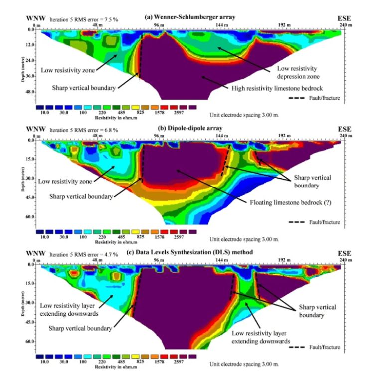
Types of Resistivity Arrays in Malaysia
Wenner
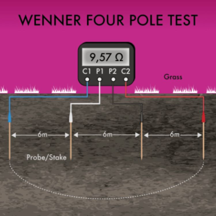
The Wenner array is one of the most widely used configurations in Malaysia because it gives high-quality resolution for shallow subsurface studies. It’s especially effective for mapping topsoil thickness, detecting shallow groundwater and assessing near-surface geology in construction sites.
Schlumberger
Favoured in groundwater exploration, the Schlumberger array allows deeper penetration with fewer electrode movements compared to Wenner. This makes it efficient for locating aquifers in rural areas or determining the depth to bedrock before large-scale infrastructure projects.
Dipole-Dipole
This array is excellent for 2D resistivity imaging, making it highly valuable in slope stability assessments, fault detection and landslide investigations. In Malaysia’s hilly terrains such as Penang and Hulu Langat, dipole-dipole surveys are frequently used to map weak zones in slopes.
Pole-Dipole
Pole-dipole arrays strike a balance between resolution and depth, making them versatile for larger survey areas like mining sites or highway alignments. While slightly less symmetrical than the other arrays, it offers robust data coverage for regional-scale investigations.
Tools & Equipment for Electrical Resistivity in Malaysia
1. Resistivity Meters – Instruments such as ABEM Terrameter are used to inject current and measure voltage differences with high accuracy.
2. Multi-Electrode Cables – Allow connection of multiple electrodes at once, enabling faster and more consistent 2D/3D surveys.
3. Electrodes & Accessories – Stainless steel or non-polarizable electrodes ensure good ground contact even in tropical soils.
4. Inversion Software (e.g., RES2DINV/RES3DINV) – Transforms raw data into clear subsurface models for interpretation.
5. Field-Proven Systems – Rugged equipment designed to perform reliably in Malaysia’s humid climate, dense vegetation and mixed terrain.
Limitation of Electrical Resistivity
Despite its power, the electrical resistivity survey method has limitations:
- Sensitive to cultural noise (power lines, buried cables).
- Requires good ground contact, difficult in rocky terrain.
- Interpretation depends on experienced geophysicists.
This is why partnering with experts matters.
“Electrical resistivity imaging and hydrochemical surveys were used to investigate the groundwater alluvial aquifer in Kuala Langat, Malaysia. The ERI and hydrochemical analyses reveal that groundwater in the study area, especially towards the coast, is a mixture of brackish and fresh waters.” — Mahmoud Khaki, Ismail Yusoff, Nur Islami; Electrical Resistivity Imaging and Hydrochemical Analysis for Groundwater Investigation in Kuala Langat, Malaysia
The electrical resistivity survey method isn’t just another tool in geo engineering, it’s the backbone of safe, cost-efficient and reliable subsurface exploration in Malaysia. At Geotechnica, we’ve seen firsthand how it prevents failures, optimizes construction and supports sustainable groundwater use.
If you’re a geologist or engineer searching for the best, remember this: resistivity surveys aren’t optional, they’re essential. And with Geotechnica, you get results faster, more accurately and at a better price than the rest of the market.
Don’t gamble with your project. Contact Geotechnica today, and let’s build Malaysia’s future on solid ground.

