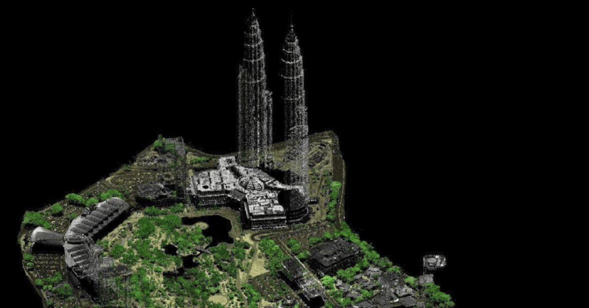
You’ve just received the results from your airborne LiDAR survey. It’s a massive digital file, millions—perhaps billions of tiny points forming a ghostly, three-dimensional image of your project site. It’s like being handed the key to a treasure chest overflowing with insights. But there’s a catch: the key is written in a language you don’t understand.
This raw point cloud is the treasure, but without the knowledge to process and interpret it, it remains locked. The true challenge and opportunity lie not in acquiring the scan, but in expertly translating this powerful LiDAR data into actionable, project-saving decisions.
Geologist is Drowning in a Sea of Points
The sheer volume and complexity of raw LiDAR data can be overwhelming. A project manager or engineer might look at a point cloud and see a chaotic swarm of dots. How do you turn this digital cloud into a contour map? How do you differentiate a treetop from a rooftop, or a shrub from the actual ground level? Without proper processing and classification, the data is functionally useless. You’ve invested in a state-of-the-art tool but can’t leverage its power. It’s a common frustration that can stall projects and lead to missed opportunities.
Services : LiDAR Mapping Service in Malaysia by Geotechnica
The Agony : The Danger of Misinterpretation
The danger of misinterpreting LiDAR data is very real. Imagine classifying a dense patch of low-lying ferns as solid ground. You might then design a building foundation on what is essentially unstable, organic material. Or consider a flood risk assessment where the digital model fails to correctly identify culverts and small bridges, leading to a completely inaccurate prediction of water flow.
“In our initial analysis of a site near a river, the raw data made it look like we had a gentle, continuous slope,” recalls a (hypothetical) GIS analyst. “It was only after a specialist firm re-processed the data, filtering out the dense vegetation and artifacts, that we saw the truth: a series of sharp, eroded gullies invisible from the air and ground. This discovery completely changed our drainage design and likely prevented a major washout during the first monsoon season.”
In a country with intense rainfall and complex topography, such mistakes aren’t just costly; they can be disastrous. This is why the first step, a high-quality LiDAR survey, must be followed by expert analysis.
Solution : Raw Points to Actionable Intelligence
Unlocking the value of LiDAR data involves a systematic process of filtering, classifying, and modeling. Here’s how our experts at Geotechnica turn that cloud of points into your most powerful planning tool.
1. The Point Cloud
The Point Cloud is the raw dataset. Each point has X, Y, and Z (elevation) coordinates, and often other attributes like intensity and return number.
2. Classification
This is the magic key of understanding the multi-layered LiDAR data. Classification is a process of using sophisticated algorithms and manual review, we classify each point. Points are tagged as ‘ground’, ‘vegetation’ (low, medium, high), ‘buildings’, ‘water’, and so on. This step is critical and requires deep expertise.

3. Digital Model Generation
Once the points are classified, we can create powerful products by using the LiDAR data such as :
i. Digital Terrain Model (DTM)
This is the ‘bare earth’ model, showing only the ground surface with all vegetation and buildings stripped away. It’s essential for hydrology, slope analysis, and understanding the true topography.
ii. Digital Surface Model (DSM)
This model shows the elevation of the first thing the laser hits be it a treetop, a roof, or the ground. It’s useful for vegetation management, line-of-sight analysis, and 3D urban modeling.
iii. Digital Elevation Model (DEM)
A general term often used interchangeably with DTM or to describe a raster (grid-based) representation of the ground elevation.
Benefits of Understanding LiDAR Data for Geologist
With these processed models, you can cleverly :
- Generate Precise Contour Maps: The foundation of all engineering design.
- Perform Slope and Aspect Analysis: Identify landslide risks and optimal locations for solar panels or crops.
- Model Water Flow and Flood Plains: Design effective drainage and mitigation systems, a critical task in Malaysia’s climate. According to news reports by BERNAMA, flood events continue to pose a significant threat, making accurate modeling more important than ever.
- Calculate Cut-and-Fill Volumes: Optimize earthworks for road and site construction, saving immense time and money.
This data is also a crucial input for any serious soil investigation, as it helps target key areas for physical sampling.
The Transformation: Data-Driven Certainty
Imagine planning a new township. With classified LiDAR data, you can instantly see the bare-earth terrain for road planning, identify the exact footprint of existing structures for demolition, calculate the height of the forest canopy to assess clearing costs, and model how rainwater will flow through the new development. Every decision is informed by precise, reliable data. This level of insight is invaluable, as seen on public data portals like those from data.nextgis.com, which showcase the power of organized geospatial information.
Read : Understanding LiDAR Meaning in Malaysia Context (2026)
The interpretation of this information is where true expertise shines. Geotechnica’s mastery in geoforensics assesment ensures that the data isn’t just processed, but analyzed with an engineer’s eye for risk and opportunity.
Raw LiDAR data holds immense potential, but its value is only unlocked through meticulous processing and intelligent interpretation. It’s the difference between having a map and knowing the way. Don’t let your investment in high-quality data go to waste. The expert team at Geotechnica can assist and guide you in transforming your complex point cloud into clear, actionable insights for your project. Connect with us and let us help you read the story the land is telling.

