Centralising Geo-Engineering Solutions
01
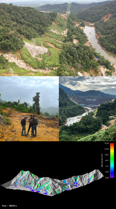
Landslide Hazard Risk Assessment at PMU Kenyir GIS
Client : Tenaga Nasional Berhad/MRSA Engineering
Consultancy Sdn Bhd
Year : 2023
Job detail:
1. Kenyir Tower Grid Line was constructed on a hillside platform which located in the middle of slope between an embankment and a natural slope. Majority of landslide were located on a steep gradient of slope coupled with the presence of water seepage and streams with fast flowing water. There is a part of the study area that has a gentle gradient of slope but situated nearby the logging and deforestation vicinity.
2. The purpose of this project is to gather information and assess the site geology, any geological limitation and geological hazards of the area and to come up with Landslide Hazard and Risk Assessment (LHA) of the study area. LHA model was made based on twelve dependent model parameters (landslide causal and triggering factors) that are then subsequently categorised into sub-classes of said dependent parameters
02
GA & Conceptual Design For Potential Slope Hazards At Jelapang
Client: PLUS Malaysia Berhad/Ranhill Engineering Consulting Sdn Bhd
Year : 2023
Job detail:
1. OPUS NMM had recorded multiple locations of potential slope hazard that might bring risk to highway user. A normal maintenance work via Work Order System could not be applied due to the scope of works need a specialist approach and it is located outside of PLUS’s ROW. PLUS Bhd is recommended to appoint External Consultant to determine the likelihood of any slope failure to occur.
2. Geohazard and risk assessment were conducted through geological mapping and aerial survey on slopes along section N5, North-South Expressway. The scope consists of investigation of the geological, geotechnical, and hydro-topographical characteristics of the incident area, evaluation of the hazard and risk of the ground and slopes towards the surrounding assets and recommendation on the mitigation measures.
03
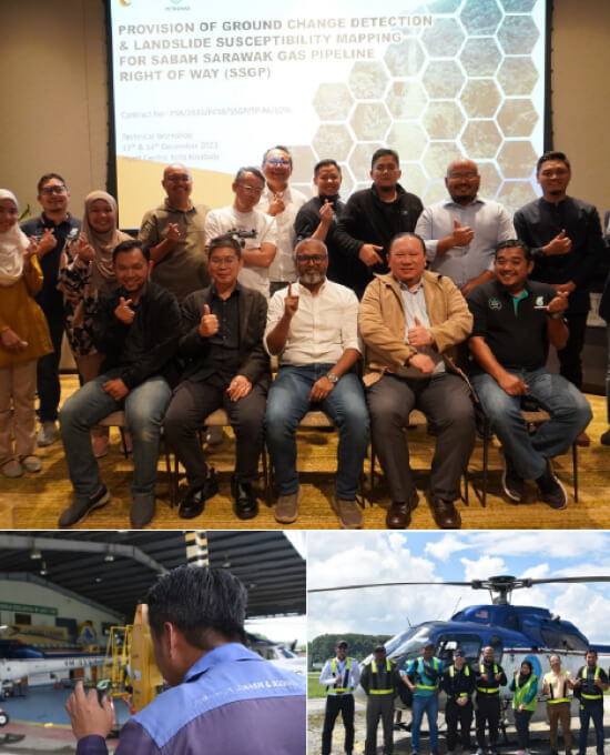
CDM and LSM for Sabah Sarawak Gas Pipeline ROW
Client : Petronas Carigali Sdn Bhd/Technovita Sdn Bhd
Year : 2023
Job detail:
1. The Right-of-Way (ROW) coverage of 4800 acres are built in mountainous region and challenging terrain, thus, this gas pipeline is exposed to many geohazards that may impact on the pipeline integrity such as pipe leak and rupture. Preventive measures need to be taken to prevent similar incidents from happening in the future in the form of production of landslide susceptibility map.
2. The primary scope of work comprises of two parts which are ground change detection and landslide susceptibility map (LSM). Ground change detection is carried out through establishment of change detection map, preparation of raster maps which include slope gradient, slope height and flow accumulation and preparation of LiDAR data. For LSM, it consisted of technical workshop, landslide inventory mapping and landslide susceptibility mapping.
04
Slope Hazard & Risk Assessment along State Road in Sarawak
Client: Jabatan Kerja Raya Sarawak / DT Consulting Engineers Sdn Bhd
Year : 2023
Job detail:
1. The Jabatan Kerja Raya Sarawak (JKRS) initiated a project to assess the slope features, hazard and risk along Jalan Raya Negeri Sarawak at Sri Aman and Betong area, which traverses through challenging mountainous terrain. Remote sensing technology was used for a full evaluation of linear based assessment along roads. Landslide causal factors were used to formulate the hazard and risk model.
2. The assessment involves the application of RS, GIS, detailed inspections of the slopes along the road, followed by conceptual design for mitigation measures was proposed for all Very High-risk rating locations
05
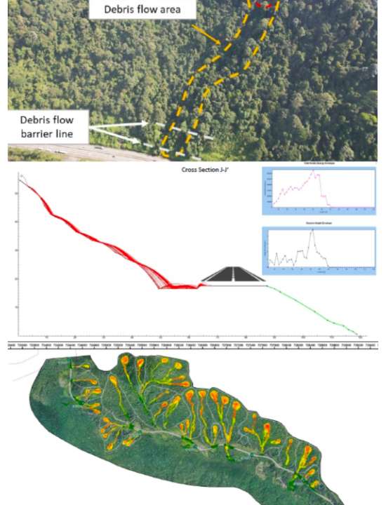
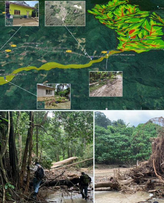
Debris Flow Assessment at Puncak Janing
Client : Jabatan Mineral & Geosains / GoGEO Engineering
Year : 2022
Job detail:
1. This project involve geological, geomorphological, and geological hazards mapping of debris flow at Taman Eko Rimba (TER) Puncak Janing in Bukit Perangin Forest Reserve. The study area is underlain by North-West Domain Granite except for the northwest area underlain by Kubang Pasu Formation. The elevation varies from 75m to 726m. Natural slopes of >35 degrees are found upstream that may trigger landslides and debris flows. Dead trees and boulders, pebbles, sand, and gravel along the river may form temporary natural dams and be sources of debris during debris flows.
2. The geological hazards map produced shows the destruction zone, danger zone, and safe zone resulting from field geological mapping, anatomy study, and geological hazards study.
Geological Terrain Mapping along 40km road alignment at Mat Daling
06
Geological Terrain Mapping along 40km road alignment at Mat Daling
Client : Euro Saga Sdn Bhd / Geoscience Solution Sdn Bhd
Year : 2022
Job detail:
1. GTSB was appointed to carry out geological terrain mapping along a 40 km Right-of-Way (ROW) for proposed state road at Mat Daling, Pahang Darul Makmur. The scope of works cover the surface geological terrain mapping carried out in August 2022 through desk study and field assessment. The site is located in a hilly area with an undulating terrain near Sungai Tembeling.
2. The mapping was done as part of requirement by government authorities such as JMG, JKR, DOE and Plan Malaysia. Features such as terrain activity, instability, slope gradient as well as geohazards along the study area were mapped and studied.

07
Engineering Geological Mapping at Pulau Redang
Client : JKR Terengganu / GoGEO Engineering
Year : 2022
Job detail:
1. Jabatan Kerja Raya (JKR) of Terengganu initiated Slope Hazard and Risk Assessment study for the development of Pusat Ummah at Kg. Baru, Pulau Redang, Terengganu Darul Iman. The aim of the assessment was to determine the likelihood of any landslide failure, the consequence and risk towards surrounding assets and facilities, and to make recommendations for mitigation action prior to any development plan implementation.
2. The assessment involved using Aerial Photogrammetry to obtain terrain information, which was used to formulate the hazard and risk model. Field data collection was carried out to ensure the risk ratings assigned are reflecting the actual site condition. A conceptual design for mitigation measures that are most appropriate for the topographical and geomorphological conditions of the site was proposed for all Very High-risk rating locations.
08
SSGP Hazard & Risk Assessment using LiDAR
Client : JKR Terengganu / GoGEO Engineering
Year : 2022
Job detail:
1. Jabatan Kerja Raya (JKR) of Terengganu initiated Slope Hazard and Risk Assessment study for the development of Pusat Ummah at Kg. Baru, Pulau Redang, Terengganu Darul Iman. The aim of the assessment was to determine the likelihood of any landslide failure, the consequence and risk towards surrounding assets and facilities, and to make recommendations for mitigation action prior to any development plan implementation.
2. The assessment involved using Aerial Photogrammetry to obtain terrain information, which was used to formulate the hazard and risk model. Field data collection was carried out to ensure the risk ratings assigned are reflecting the actual site condition. A conceptual design for mitigation measures that are most appropriate for the topographical and geomorphological conditions of the site was proposed for all Very High-risk rating locations.
09
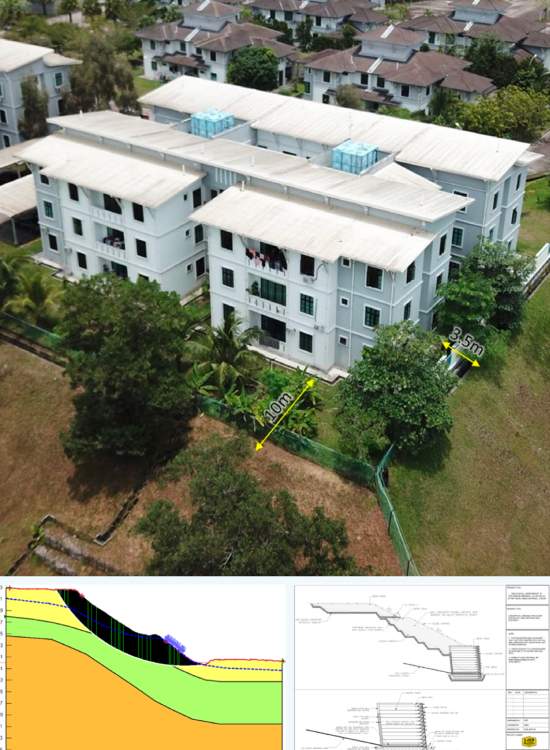
Engineering Geological Mapping at Politeknik Mersing
Client : JKR Cawangan Cerun / GoGEO Engineering
Year : 2022
Job detail:
1. The project involved geological assessment carried out for Jabatan Kerja Raya Malaysia to improve failed slopes at
Politeknik Mersing, Johor. The scope cover desk study and field assessment, which revealed that the proposed development area is characterized by phyllite, slate, shale, and sandstone of the Mersing Formation. Signs of distress were observed across the site, possibly due to ineffective drainage systems and the presence of fill materials consisting of mixed grains, predominantly clay.
2. Slope stability analyses were performed at two sites, which resulted in a factor of safety lower than the recommendations by JKR. The report provides conclusions and recommendations based on the assessment and analyses performed.
10
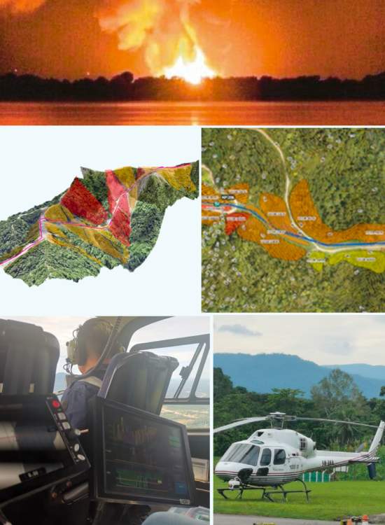
Geoforensic Assessment at TULIP Pipeline ROW
Client : Petronas Gas Berhad / Axianergy (M) Sdn. Bhd.
Year : 2022
Job detail:
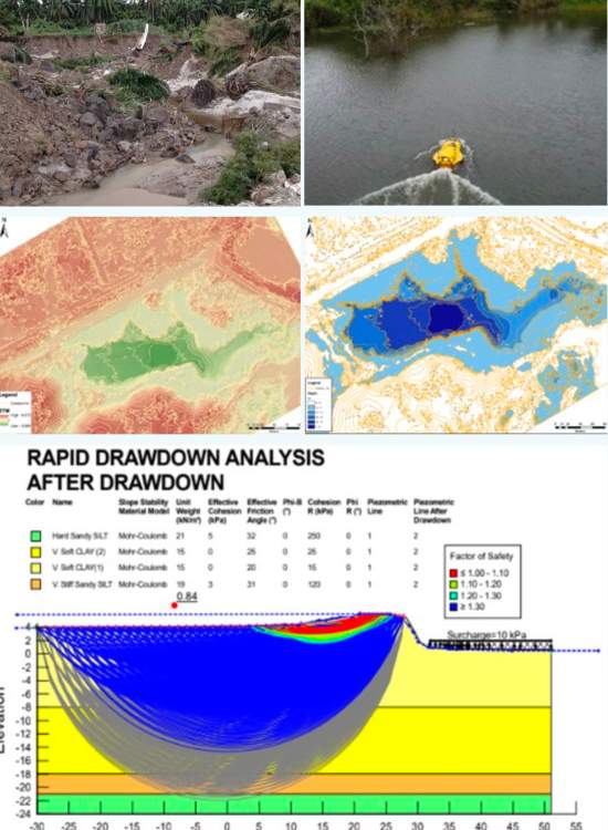
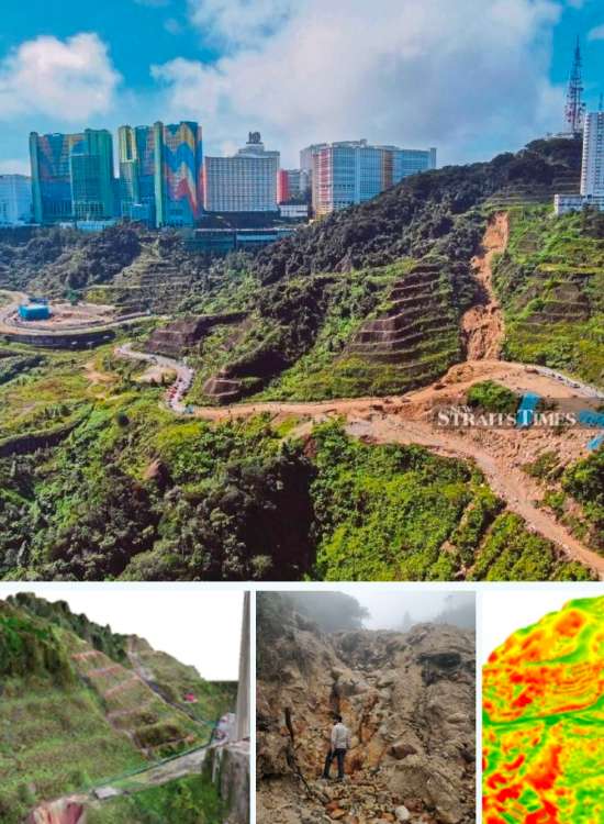
1. In December 2022, a combined flood and landslide event occurred near Kg Lombong, which affected a portion of the TULIP pipeline right-of-way (ROW) and was suspected to have been triggered by heavy rainfall. The objective of this
project is to perform an assessment and identify the
possible root cause of the failure.
2. This project involves a multidisciplinary assessment in the fields of geology, geotechnics, geospatial analysis, and
hydrology. Unmanned vehicles of USV and UAV were
deployed to generate a comprehensive model that
combines on-ground and underwater-bed topography.

11
Geoforensic Assessment at Lawas (KP139), SSGP
Client : Petronas Carigali Sdn. Bhd. / DNASB
Year : 2021
Job detail:
1. In December 2020, an incident of pipeline failure was
reported at the Sabah-Sarawak Gas Pipeline (SSGP)
right-of-way in Lawas, Sarawak, resulting in a loss of
production capacity (LOPC).
2. The incident was initially suspected to have been
triggered by a landslide. The objective of this project is to
conduct an assessment to determine the possible root
cause(s) of the failure.
3. This project involves a team of multidisciplinary experts
from the fields of geology, geotechnics, geospatial
analysis, and hydrology, who collaborated to investigate
the incident and identify the underlying causes.
12
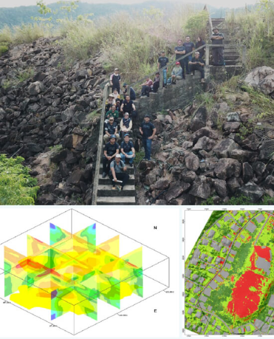
Assessment of Critical Slope in Selangor, N. Sembilan & Melaka
Client : JMG Selangor & Negeri Sembilan / GoGEO Engineering
Year : 2021
Job detail:
1. Based on “Penghasilan Peta Bahaya dan Risiko Cerun di
Kawasan Gombak-Selayang-Rawang-Batang Kali, Selangor dan Cheras Selatan-Kajang-Bangi, Selangor” study in 2017, 20 numbers of locations were identified as critical slopes.
2. The objective of this project is to assess and update the current hazard and risk rating according to Slope Information Management System which involve 6 PBT’s for Selangor i.e. MPKJ, MPAJ, MP Selayang, MD Hulu Langat, MP Sepang and DBKL; and 6 PBT’s in Negeri Sembilan i.e. MP Seremban, MD Jelebu, MP Port Dickson, MD Tampin, MP Alor Gajah and MB Melaka.
13
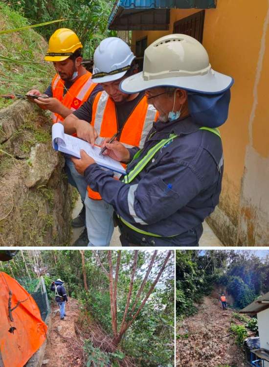
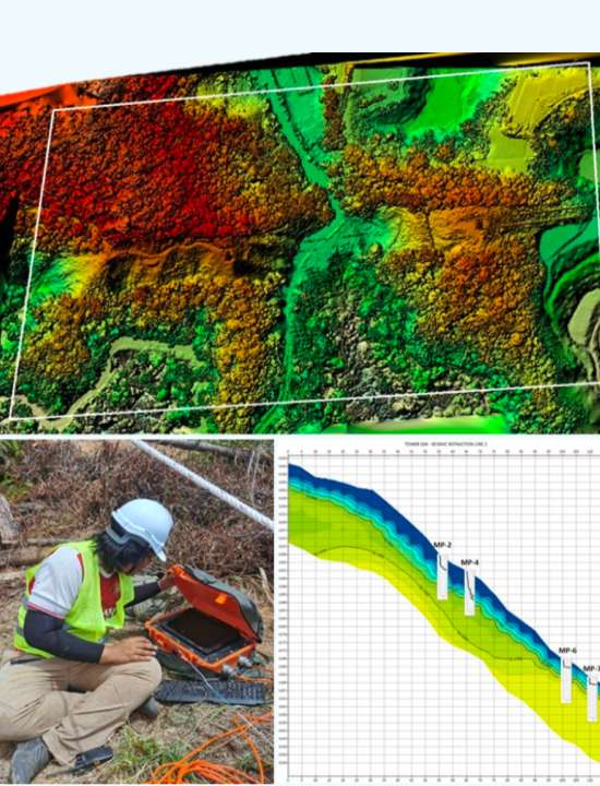
Geohazard Assessment at Ringlet, Cameron Highlands
Client : TNB / Minconsult Sdn Bhd
Year : 2021
Job detail:
1. Geohazards assessment was conducted at the section of the TNB 275kV right-of-way, which was identified as requiring urgent attention following the landslide incidents. The assessment included soil investigation, geophysical seismic survey, and LiDAR acquisition. The Slope Information Management System (SIMS) was adopted to determine the hazard rating for each slope using parameters such as topography, slope geometry, and geological.
2. The study revealed that heavy rainfall, geomorphology, and geologic material of the area, human activities, and adverse geological features were the main contributors to the slope failures. Interim mitigation measures were proposed prior to permanent rectification, which included short and long-term solutions.
14
Detailed Geological Assessment at KP220 of SSGP
Client : PETRONAS Carigali Sdn Bhd / WHA Sdn Bhd
Year : 2022
Job detail:
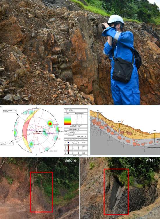
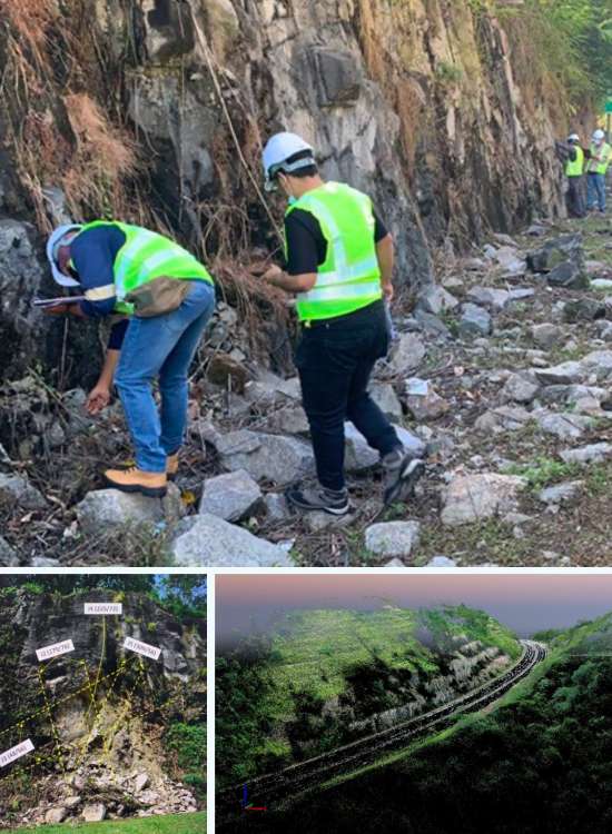
1. In November 2021, a pipeline dig up activity revealed a
pipeline parting at SSGP ROW, suspected to be caused
by geohazard. Geotechnica Sdn Bhd, in association with
Wan Husin & Associates Sdn Bhd, was appointed to
perform a geological assessment and recommend
mitigation action.
2. Field assessment showed high deformation and active
slope movement with signs of distress and geological
structures such as fault, buckling, boudinage, tension
cracks and water seepage. Kinematic analysis and XRD
testing identified potential sliding, wedge and toppling
failure, and revealed intense weathering and deformation.
Immediate and permanent remedial works were
recommended to prevent further deterioration.
15
Geohazard Assessment at Amber Courts, Genting Highlands
Client : Amber Courts / Geoventure Sollution Sdn Bhd
Year : 2020
Job detail:
1. A landslide was reported occurred at Jalan Genting-
Amber Court in Genting Highlands around 5.40pm on 5
Nov 2019 (Tuesday) affecting the main access road. The
failed slope approx. 95m in height, consist of 21 numbers
of berm located at the toe of Amber Court Apartment.
However, no casualties were reported.
2. The scope of work was to conduct a site reconnaissance
at the location, assess the site condition, identify any
adverse geological features, and determine the possible
root cause of the landslide. Several analyses were carried
out, including GIS/geospatial, kinematic, and stability
analysis
16
Rock Slope Risk Assessment along Kajang SILK Highway
Client : PROLINTAS SILK / EGEO Consult Sdn. Bhd.
Year : 2021
Job detail:
1. Several rock slope failures have been reported to occur along this highway since 2009. However, no casualties have ever been reported following the incidents. Therefore, a comprehensive study is necessary to assess the safety of the slope and its surrounding area.
2. The objective of this study is to assess the likelihood and
consequences of failure due to rock slope hazards and determine the actions required to reduce the risk. This includes the development of hazard-risk maps, conceptualization of mitigation and remediation activities to reduce the occurrence or magnitude of hazardous events and to minimize the consequences following such events.
17
Detail Design for Slope Stabilization at Kajang SILK
Client : PROLINTAS SILK / EGEO Consult Sdn. Bhd.
Year : 2021
Job detail:
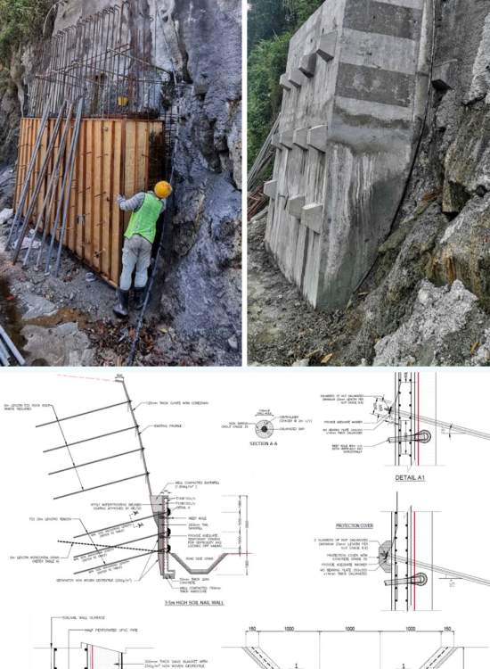
1. In continuation of the Rock Slope Hazard and Risk
Assessment, the locations identified with a Very High
rating and showing signs of distress and failure were
addressed and mitigated. This was done to ensure the
safety and stability of the slope, as well as to prevent
potential hazards that could impact the surrounding area.
2. The scope of work involved in this project includes
engineering topographical surveys, detailed engineering
design, establishment of AFC (Approved For
Construction) drawings, slope rectification, and site
supervision. These activities are crucial for ensuring that
the slope is designed and constructed in accordance with
the required standards and specifications, and that it is
stable and safe for long-term use.
18
Rock Slope Assessment at PJU8 Bukit Lanjan
Client : Vestland / Max Engineering Sdn Bhd
Year : 2022
Job detail:
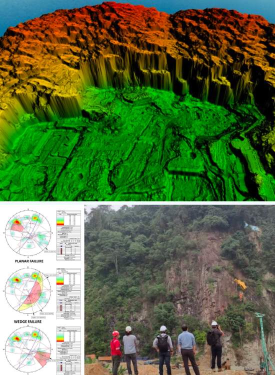
1. Geologically, any type of rocks is subjected to at least a
primary structure (i.e. beddings, unconformities, etc.)
and/or secondary structures (i.e. foliation, joint, faults
etc.). These structures usually were generalized as planes
of discontinuities where it is classified as weak region of
the rock mass. In worst case, intersections of any of these
structures may lead to rock slope failures by either falls
or/and rock slides. Hence, it is important to map out all
2. relevant structures that attributed to the rock mass
integrity.The main objectives of the studies, amongst
others, are to identify the physical geologic characteristics
of the area, notably the geological features and processes
that might induce geological hazards to the proposed
development, human lives and activities, and to facilitate
the design and selection of most suitable mitigation
measures for risks of landslide and/or rock slope failures.

Navigation Panel
Contact Us
GEOTECHNICA SDN BHD
48-1, Jalan Aman Sinaria 4,
Bandar Tropicana Aman,
42500 Rimbayu, Selangor
Tel: 03-8683 6682
Email: admin@geotechnica.com.my
All rights reserved. Copyright © 2025 GEOTECHNICA SDN BHD