Since 2025 challenges of flash floods, soil stability, and rapid urbanization intersect, there is a pressing need for new ways to understand and manage the environment. The Augmented Reality Sandbox (AR Sandbox) is emerging as one such innovation. It combines the tactile experience of shaping sand with the power of augmented reality, producing interactive topographic models that can respond instantly to human input.
While this technology has been widely studied and implemented in the United States and Europe, its arrival in Malaysia signals a new era of geotechnical education, hydrology research, and infrastructure planning.
“Technology is not just a tool, it can shape how we see and understand the world around us” – Stanford University Virtual Human Interaction Lab.
What is an Augmented Reality Sandbox?
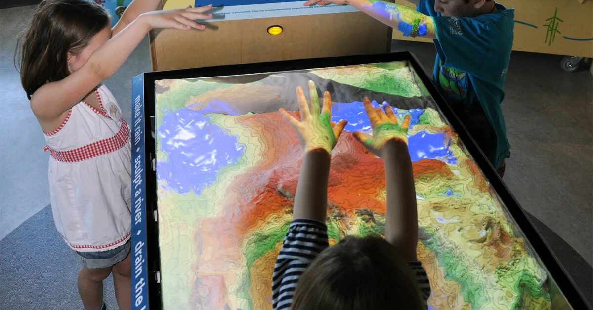
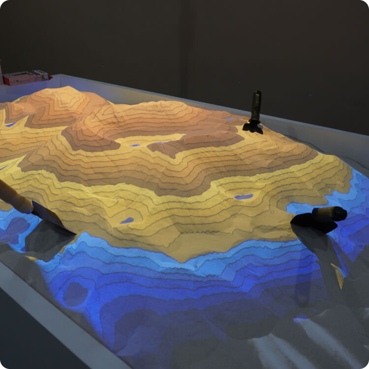
At its core, the Augmented Reality Sandbox is a physical sandbox enhanced by a depth sensor and projector system. As the user shapes the sand to create mountains, valleys, or rivers, the technology overlays a dynamic digital display that projects contour lines, elevation data, and even water simulations in real time. This creates a unique blend of hands-on interaction and scientific visualization, turning simple sand play into a sophisticated model of the earth’s surface.
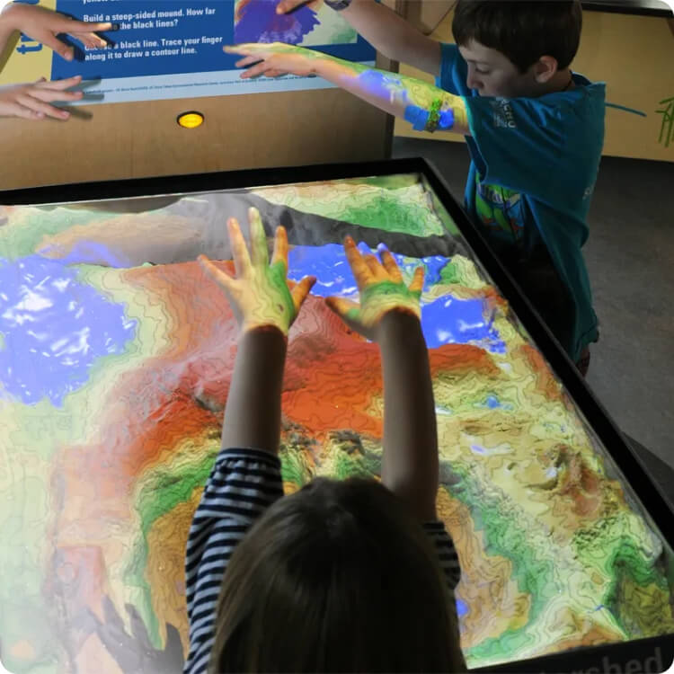
Unlike static maps or digital-only simulations, AR Sandbox bridges the gap between physical modeling and virtual representation. By doing so, it offers users, whether they are students, engineers, or researchers, a more intuitive way to grasp the relationships between landforms, water flow, and human activity.
Read : Importance of Geotechnical Engineering (Malaysia Edition)
Why is AR Sandbox Important in Malaysia?
Malaysia’s geographical and environmental context makes the AR Sandbox especially valuable. The country experiences annual monsoons that frequently lead to flooding, and many urban areas continue to expand into previously undeveloped or flood-prone zones. Hillside developments, too, face risks of soil instability and landslides. These are not abstract issues; they directly affect safety, infrastructure, and economic resilience.
The AR Sandbox provides a way to simulate these scenarios in controlled environments. For instance, by reshaping sand into a low-lying basin, researchers can demonstrate how water accumulates during heavy rainfall. By adjusting slopes, they can illustrate how soil movement might occur during a landslide. These simulations make abstract risks visible and tangible, offering insights for urban planners, disaster management agencies, and geotechnical engineers.
In education, the benefits are equally significant. Students in geography or civil engineering often struggle with the leap from textbook diagrams to real-world terrain. With AR Sandbox, they can manipulate the landscape directly and see the immediate impact of their changes, reinforcing learning through experience.
In Malaysia, augmented reality is reshaping engineering education by making learning more interactive and bridging theory with real-world application
How Does AR Sandbox Support Education and Research?
The Malaysian education system has made strides toward integrating more interactive technologies, especially in STEM fields. The AR Sandbox fits seamlessly into this vision. In university classrooms, it allows students to explore the fundamentals of geoscience, hydrology, and soil mechanics in a way that feels immersive and memorable. Rather than passively observing, they actively shape terrain, test water flow, and experiment with slope gradients.
For researchers, the sandbox becomes more than an educational tool. It can be used to model flood scenarios in cities like Kuala Lumpur, Johor Bahru, or Penang, where urban density and drainage limitations make flooding a recurring problem. Similarly, hydrology experts can simulate how rainfall patterns impact river systems in flood-prone states such as Kelantan and Pahang. These models are not merely academic, they can inform policy, planning, and disaster preparedness strategies.
When & Where Can AR Sandbox Be Applied in Malaysia?
The applications of AR Sandbox are diverse and cross-disciplinary, making it relevant to multiple sectors in Malaysia. In education, it is best suited for universities, technical colleges, and schools that emphasize STEM education. In geotechnical engineering, it can be deployed in laboratories where soil mechanics and slope stability are studied.

Government agencies tasked with disaster preparedness can use it to simulate flooding events, test urban drainage strategies, and prepare communities for the realities of climate change. Urban planning councils, meanwhile, can use AR Sandbox as a communication tool, helping stakeholders visualize how proposed developments may interact with the natural terrain.
The timing for adoption could not be more critical. With Malaysia experiencing increasingly severe weather patterns due to climate change, coupled with the demand for sustainable urban expansion, adopting tools like AR Sandbox is not a matter of convenience but of necessity. Integrating this technology now will prepare institutions and agencies to respond to tomorrow’s challenges more effectively.
BOOK NOW : AUGMENTED REALITY SANDBOX MALAYSIA
The Future of AR Sandbox in Malaysia
As Malaysia moves toward Industry 4.0 and smart city development, technologies like AR Sandbox will play an even more prominent role. When integrated with Geographic Information Systems (GIS) and hydrological data, the sandbox could become a vital instrument in predictive modeling. Imagine a city council being able to demonstrate, in real time, how a proposed housing project might affect water run-off or increase flood risk. Such tools not only enhance technical accuracy but also improve communication between experts and the public.
In geotechnical consultancy, AR Sandbox can strengthen decision-making processes by offering visual evidence that supports planning documents and risk assessments. In education, its adoption in STEM hubs and universities will ensure that Malaysia’s next generation of engineers and scientists are not only well-informed but also equipped with hands-on skills. The trajectory is clear: AR Sandbox will evolve from a niche tool into a mainstream solution for Malaysia’s educational and environmental future.
Read : Types of Soil Investigation Test by Geotechnica

Conclusion
“We cannot solve our problems with the same thinking we used when we created them” – Albert Einstein
The Augmented Reality Sandbox represents more than a technological novelty; it is a transformative tool for Malaysia’s education, research, and geotechnical planning. By making complex systems visible and interactive, it equips students with deeper learning experiences, empowers researchers with more accurate models, and supports policymakers with data-driven insights.
At Geotechnica, we are committed to bridging innovation with practical application. Our expertise in geotechnical solutions and interactive technologies allows us to deliver Augmented Reality Sandbox systems tailored for universities, research institutions, engineering firms, and government agencies across Malaysia. We believe that the future of geotechnical learning and sustainable planning starts with tools that bring science to life.
If your institution or organization is ready to explore how Augmented Reality Sandbox can transform learning, research, and decision-making, connect with Geotechnica today. Together, we can turn technology into lasting impact.
BOOK NOW : AUGMENTED REALITY SANDBOX MALAYSIA

