
Many people assume that the geological map Malaysia is only an academic reference, a dusty chart reserved for researchers or government archives. The stigma is that it’s outdated, too complex, or irrelevant for modern industries. In reality, the lack of understanding and limited accessibility to reliable geological data often creates pain for engineers, urban planners, and even policymakers leading to costly errors in construction, infrastructure failures, and misinformed decisions about land use.
This article dives deep into what the geological map Malaysia truly represents, how the engineering geological map, subsurface geology map, and tectonic map of Peninsular Malaysia are used in practice, and why this matters for modern geologists and engineers operating in Malaysia. Expect data, case studies, and actionable guidance.
There’s a common misconception that accessing the geological map of Malaysia is difficult, outdated, or too generalized. Engineers often misunderstand the level of detail, scale, or digitization (e.g., “where to get geological map Malaysia” queries).
Many practitioners confuse surface geology with engineering-specific soil and rock layer mapping, or underestimate the value of quaternary deposits map Malaysia. These misconceptions can lead to flawed construction feasibility study or land use planning Malaysia.
By the end of this guide, you’ll understand how accurate geological mapping Malaysia, 3D geological map Malaysia and hydrogeological mapping improve infrastructure planning, support mineral exploration and mitigate seismic and landslide hazards.
“Geologic maps enhance our ability to site and build the nation’s infrastructure … and to make more informed land‑use and planning decisions to meet societal needs.” — Geological Society of America (GSA) Position Statement
What is a Geological Map?
A geological map portrays rock and soil formation, lithological classification, stratigraphic profiles, fault lines and bedrock geology. It integrates surface geology interpretation, geological cross‑section Malaysia, and geological unit boundary data. These are the cornerstones of mapping subsurface features via borehole data and terrain overlays for accurate engineering geological map insights.
Geological Map In Malaysia
In Malaysia, the geological map Malaysia is compiled by JMG (formerly Geological Survey of Malaysia). The current baseline is JMG’s 1:1 million combined bedrock and superficial geology map of Peninsular Malaysia.
Detailed quadrangles (scales up to 1 : 50,000) are available for state level analysis and data are accessible via JMG’s MyGEMS portal and Borehole GeoHUB.
These provide essential engineering geological map, rock and soil layer mapping, borehole data interpretation and geological field mapping.
Scale Used in Malaysia’s Geological Map
In Malaysia, geological maps are published at a variety of scales depending on the purpose and regional coverage. These maps range from broad national overviews to detailed terrain level sheets essential for geotechnical site studies, land-use planning and geohazard assessments.
1 : 50,000 Scale
This is the most commonly used scale for detailed geological mapping in Peninsular Malaysia and selected areas of Sarawak and Sabah. It provides high resolution geological information crucial for rock and soil formation mapping, slope geology mapping and engineering geological map development.
1 : 125,000 Scale
Used in parts of Sabah and Sarawak, this intermediate scale offers a balance between regional coverage and geological detail, often supporting fault line mapping and soil investigation reports.
1 : 250,000 Scale
Applied across various regions in Malaysia, this scale is suitable for broad geological assessments, quaternary deposits map Malaysia and stratigraphic profile Malaysia.
1 : 500,000 Scale
Commonly used in hydrogeological mapping, mineral resource mapping and national level geohazard assessment programs. It provides a generalized view of subsurface geology and bedrock formations.
1 : 750,000 Scale
Notably, the 8th edition of the Geological Map of Peninsular Malaysia, published in 1985, was issued at this scale, offering a semi detailed overview of regional lithology and tectonic features.
1 : 1,000,000 Scale
This national scale map was produced by the Geological Society of Malaysia and University of Malaya for use in educational, academic and strategic infrastructure planning. It covers broad bedrock-superficial geology, tectonic zones and geological unit boundaries across Peninsular Malaysia.
Purpose of Geological Mapping
- Infrastructure planning such as integrated geological hazard mapping, slope geology mapping, fault line mapping Malaysia.
- Mining & mineral resource mapping include locating rare earth, tin, bauxite via mineral resource mapping.
- Hydrogeology & groundwater potential mapping.
- Geotechnical site study and soil investigation report.
- Geohazard assessment including landslide‑prone area identification, sinkhole mapping.
Geological Map of Malaysia: 2025 Update
In 2025, Malaysia is rolling out its first fully digitized geological map Malaysia with GIS layers accessible through MyGEMS not only traditional maps but digital geological terrain classification, updated bedrock geology map and quaternary deposits map Malaysia.
Geotechnica leverages this directly in our workflows, producing accurate subsurface geology maps and fault line mapping Malaysia for engineering projects.
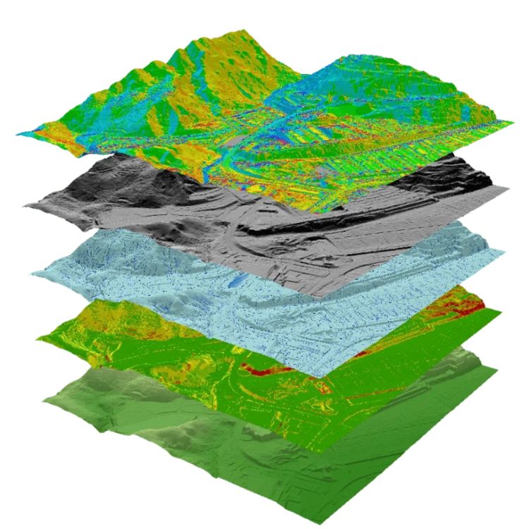
3D Geological Mapping in Malaysia
Urban Underground Planning
Our Geotechnica team uses JMG’s borehole GeoHUB and integrates engineering geological map data to produce 3D models (e.g., 3DKL model for Kuala Lumpur). This aids underground infrastructure feasibility in dense urban zones.
Landslide Hazard Zoning
We combine satellite‑based remote sensing and DEM data with JMG geological maps Penang Island landslide susceptibility mapping achieved +83 % accuracy with multi‑geophysical methods. Gunung Lang 3D rockfall modeling showed velocities up to 36 m/s using high‑resolution DEM data
Hydrogeological Modeling
Geotechnica integrates groundwater potential mapping via GIS and remote sensing data, aligning with hydrogeological mapping standards, emphasizing aquifer depths and recharge zones.
Mineral Exploration
Our mapping supports rare earth surveys (e.g. Pahang, 2025) via combined lithological and structural data to target economically viable zones.
Earthquake Fault Modeling
Integration of the tectonic map of Peninsular Malaysia, fault mapping and subsurface models enhances seismic risk analysis for critical infrastructure.
Geological Case Studies in Malaysia
Pahang Rare Earth Survey (2025)
Utilized updated geological map Malaysia, lithological classification and 3D borehole based subsurface mapping to pinpoint rare earth bearing host strata.
Sabah 3D Fault Mapping (2024)
Mapped active fault zones in Sabah with borehole logs, structure lineament mapping, fault line mapping Malaysia and remote sensing overlays to support seismic hazard mitigation.
Penang Hill Slope Study (2023)
Conducted slope geology mapping, landslide susceptibility models with remote sensing & ERT/SRT for Penang Island, yielding reliable hazard zoning maps for planners.
Klang Valley MRT Phase 3
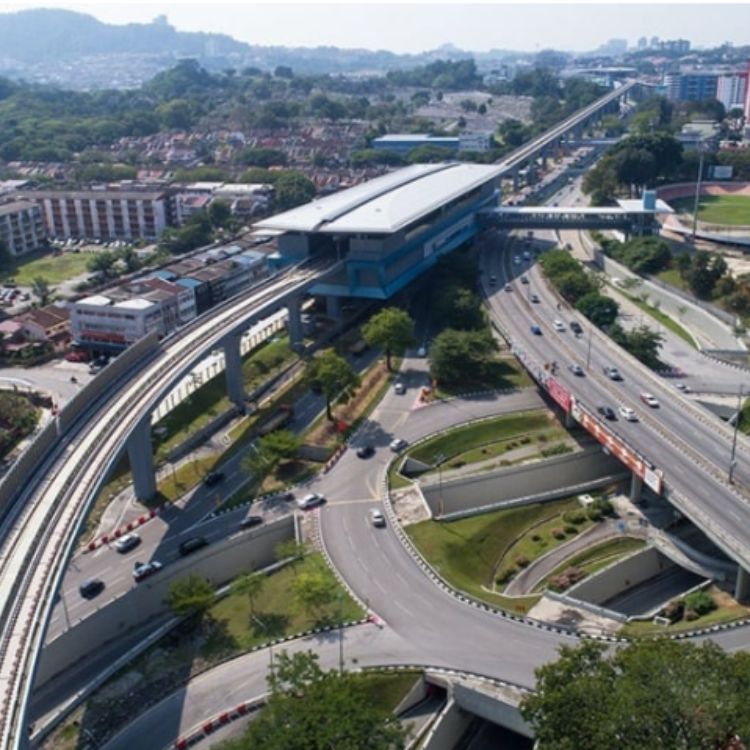
Geotechnical baseline based on detailed subsurface geology map of Klang Valley, integrating JMG data, borehole records and 3DKL model to support tunneling feasibility and risk mitigation.
“Engineering ground condition mapping and hazard mapping are integral parts of geological mapping, directly guide strategic planning for resilience and infrastructure safety”
— Integration of Geoscience Information for Disaster Resilience in Kuala Lumpur, Malaysia
In summary, the geological map Malaysia, especially the updated 2025 digital 3D model is indispensable for accurate geological hazard mapping, subsurface geology modeling and engineering planning.
Understanding and using the geological map of Malaysia, especially its 3D and hazard‑aware capabilities, is vital for safer, more efficient infrastructure, mineral and urban developments.
At Geotechnica, our service combines JMG’s authoritative data with expert interpretation in engineering geological map, geohazard assessment, soil and rock layer mapping, borehole data interpretation and GIS geological database. We offer premium quality and affordable pricing outperforming competitors in precision and turnaround.
Why Geotechnica is your best choice:
- We use official JMG data via MyGEMS and GeoHUB for geological map Malaysia accuracy.
- We deliver 3D geological models tailored for urban planning, mineral exploration, slope hazard zoning and more.
- Our workflows integrate remote sensing, DEM, borehole logs, structure mapping, yielding engineering grade deliverables.
Contact Geotechnica today to access the best choice in Malaysia for geological mapping services and get high‑quality results at competitive rates.

