Outcome / Problem (+)
What it helps determine
Turns aerial imagery into accurate maps, 3D models, and measurements of the ground surface — giving fast, cost-effective spatial data for large or hard-to-reach sites without physical contact.
Specific evidence
Terrain elevation and surface profile, volumetric and area measurements, land parcel boundaries, vegetation and crop health indices, before/after change over time.
Definition / Methodology
Core concepts
Aerial photogrammetry surveying is a method of capturing images from drones or aircraft to create accurate maps, 3D models, and measurements of the earth's surface — using overlapping photos and software to generate detailed spatial data.
Technical components
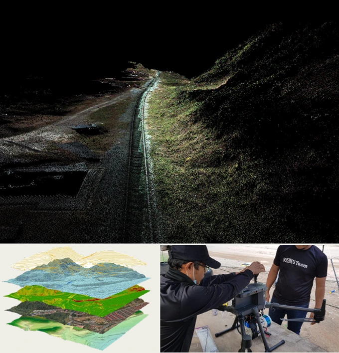
Drone or aircraft image capture with overlap, ground control points for accuracy, and photogrammetry software to generate point clouds, meshes, orthophotos and DEM/DTM outputs.

Applications
Where this service is used
01
3D Modeling
Creates accurate 3D models of terrain, structures, and landscapes for planning and visualization.
- Drone Image Capture & Overlap
- Point Cloud & Mesh Generation
- 3D Site Reconstruction & Export
02
Forestry Studies
Monitors forest health, canopy density, and tree count using aerial imagery and vegetation indices.
- Forest Cover Mapping
- Tree Height & Health Analysis
- Biomass & Carbon Estimation
03
Disaster Assessment
Provides rapid aerial mapping of affected areas for post-disaster response and recovery planning.
- Hazard Impact Mapping
- Before/After Image Comparison
- Damage Area Documentation
04
Topographic Mapping
Generates high-resolution topographic maps, contours, and elevation data for engineering.
- DEM/DTM Generation
- Contour Line Extraction
- Surface Analysis & Grading
05
Agriculture Monitoring
Uses drone imagery to monitor crop health, detect issues, and optimize field productivity.
- Field Zone Mapping
- NDVI Vegetation Analysis
- Irrigation & Pest Detection
06
Surveying & Land Planning
Supports land development and planning through accurate aerial surveys and boundary mapping.
- Land Parcel Mapping
- Area & Volume Calculation
- Integration & GIS/CAD for Planning
Process
How the assessment is carried out
01
Flight Planning & CAAM Clearance
Site scoping, flight path design, and airspace approval before mobilisation.
02
Aerial Image Capture
Drone or aircraft captures hundreds to thousands of overlapping high-resolution photos.
03
Photogrammetric Processing
Images stitched and processed into point clouds, meshes, and orthophotos.
04
Deliverable Generation
Final 3D models, DEM/DTM, contours and measurement data prepared for handover.
Equipment & Technology Capabilities / Methods
What we use in the field


Outputs / Deliverables
What you receive
3D models & point clouds
Orthophotos
DEM / DTM & contour maps
Volume & area measurements
GIS/CAD-ready datasets
Malaysian Context
Why this matters here
Local condition
Malaysia's large or hard-to-reach sites — hillside developments, plantations, remote ROWs — make ground survey slow, while CAAM regulates all drone flight operations.
Implication
Aerial photogrammetry gives fast, cost-effective coverage of large or difficult terrain, with every flight planned and cleared under CAAM regulations.
Integration / Related Services
Often paired with
LiDAR
LiDAR performs better under dense canopy; photogrammetry is more cost-effective for visible features.
Slope Hazard Assessment
Photogrammetry-derived terrain models feed slope stability and risk mapping.
Geological Map Assessment
Aerial imagery supports large-area terrain and geological mapping.
Case Study
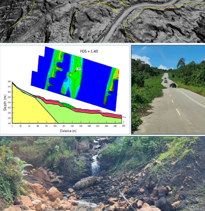
Slope Hazard & Risk Assessment at Pusat Ummah, Pulau Redang
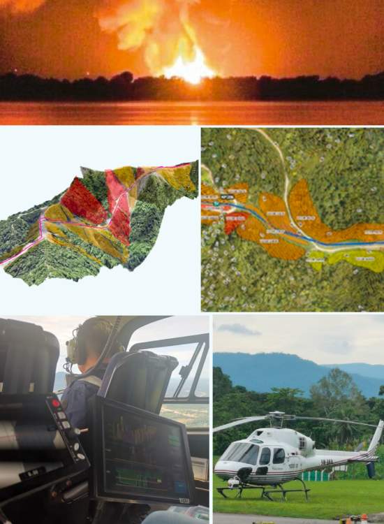
2022 · JKR Terengganu / GoGEO Engineering
Challenge
JKR Terengganu required a slope hazard and risk assessment for the proposed Pusat Ummah development at Kg. Baru, Pulau Redang — to determine landslide failure likelihood and risk to surrounding assets and facilities.
Approach
Aerial Photogrammetry was used to obtain terrain information, with field data collection conducted to confirm the assigned hazard and risk ratings reflected actual site conditions.
Finding
Several locations across the site were rated Very High risk.
Outcome
Conceptual mitigation designs were proposed for all Very High-risk locations, informing the development plan before implementation.
Standards / Compliance
All drone-based aerial photogrammetry operations are flown under full compliance with Civil Aviation Authority Malaysia (CAAM) regulations, delivering output compatible with major GIS and CAD platforms.
Standards / Compliance
Proof points
01
High-End Equipment — equipped with high-resolution drone cameras and mapping software for 100% accuracy of data & statistics.
02
National-Level Project Experience — since 2020, we've handled 20+ state and national-level aerial mapping and geotechnical projects.
03
Certified Engineers & Surveyors — our engineers & surveyors are international and local graduates with extensive geo-engineering experience.
04
Custom Report & GIS Integration — you'll receive 100% accurate reporting documents with GIS integration where needed.
FAQ
Frequently asked questions
What is aerial photogrammetry surveying?
It’s a method of using drones or aircraft to capture overlapping images and generate accurate maps, 3D models, and measurements of the ground surface.
How does drone photogrammetry work?
A drone flies over the site, takes high-resolution photos from above, and specialized software stitches the images into orthophotos and 3D models.
What are the benefits of aerial photogrammetry in Malaysia?
It’s fast, cost-effective, and ideal for large or hard-to-access areas—especially useful in construction, agriculture, disaster zones, and land planning.
What industries use aerial photogrammetry services?
Industries like construction, mining, agriculture, forestry, urban planning, and environmental monitoring benefit from drone-based mapping.
Can aerial photogrammetry be used for topographic mapping?
Yes. It can generate detailed topographic data including contours, Digital Elevation Models (DEM), and surface profiles for engineering projects.
What’s the difference between LiDAR and photogrammetry?
LiDAR uses laser pulses for mapping, while photogrammetry uses images. Photogrammetry is more cost-effective for visible features, but LiDAR performs better in dense vegetation.
Is aerial photogrammetry accurate enough for surveying?
Yes. When properly planned with ground control points, it can achieve high accuracy suitable for engineering, planning, and boundary mapping.
Can drone mapping help with agriculture monitoring?
Absolutely. Aerial surveys can detect crop health, irrigation issues, and growth variations using vegetation indices like NDVI.
Is aerial photogrammetry useful during disasters?
Yes. It allows rapid post-disaster assessment by mapping damage areas, monitoring landslides, and helping emergency teams visualize the situation.
Why choose Geotechnica for aerial photogrammetry in Malaysia?
Geotechnica combines drone technology, expert analysis, and GIS integration to deliver accurate aerial mapping services tailored for Malaysian terrain and projects.
gallery
Project photography