

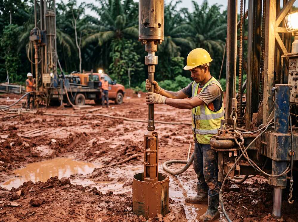
- A borehole test involves drilling into the ground to collect soil/rock samples and measure soil properties at various depths.
- The Standard Penetration Test (SPT) is the most common in-situ test performed during borehole drilling in Malaysia, producing N-values that indicate soil strength.
- Borehole tests determine bearing capacity, identify weak layers, detect groundwater and inform foundation design.
- In Malaysia, borehole testing is required for most development plan submissions and is standard practice for all building and infrastructure projects.
- A typical borehole test report includes borehole logs, SPT profiles, soil descriptions, laboratory results and geotechnical recommendations.
What Is a Borehole Test?
A borehole test is a geotechnical investigation method that involves drilling a narrow hole — typically 100 mm to 150 mm in diameter — into the ground to examine subsurface conditions. During drilling, soil and rock samples are collected at regular intervals, and field tests are conducted to measure the physical and mechanical properties of the ground.
The term “borehole test” is commonly used in Malaysia to describe the combined process of borehole drilling, sampling and in-situ testing — most notably the Standard Penetration Test (SPT). The data collected is compiled into a borehole log, which is the primary document engineers use to understand ground conditions at a specific location.
Borehole testing is not the same as simply “drilling a hole.” It is a controlled, standardised process governed by engineering standards (BS 5930, BS EN ISO 22476) and must be supervised by qualified geotechnical professionals to produce reliable data.
Why Borehole Testing Is Essential Before Construction
Determine Soil Bearing Capacity
The SPT N-values obtained during borehole testing directly indicate how strong or weak the soil is at each depth. Engineers use this data to calculate allowable bearing capacity — the maximum load the ground can safely support — which determines the type and size of foundation required.
Identify Subsurface Hazards
Borehole tests reveal hidden ground problems that are invisible from the surface: soft clay layers, loose fill, underground voids in limestone terrain, high groundwater levels, organic soils and buried obstructions. Discovering these during the design phase is infinitely cheaper than discovering them during construction.
Inform Foundation Design & Piling Depth
Without borehole data, pile lengths are estimated — often inaccurately. Borehole logs show exactly where competent bearing layers exist, allowing engineers to specify pile toe levels with confidence. This prevents under-designed piles (safety risk) and over-designed piles (unnecessary cost).
Who Needs Borehole Testing?
- Structural engineers — to design foundations based on actual ground data rather than assumptions.
- Geotechnical engineers — to assess ground conditions, slope stability and settlement potential.
- Developers & project owners — to understand site constraints and budget for appropriate foundations.
- Contractors — to accurately price piling and earthworks during tendering.
- Architects — to account for site-specific constraints in building layout and basement design.
- Government agencies — for public infrastructure including roads, bridges, utilities and public housing.
Any project that involves a foundation — from a single bungalow to a multi-storey tower or highway bridge — benefits from borehole testing.
How Does Borehole Testing Work?
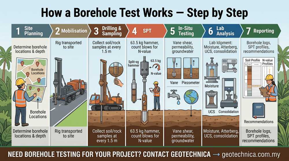
Step 1 — Site Planning & Borehole Layout
A geotechnical consultant reviews the proposed development plan and determines the number of boreholes, their locations and the required depth. Borehole positions are typically placed at building corners, heavily loaded areas and areas with suspected variable ground conditions.
Step 2 — Mobilisation & Setup
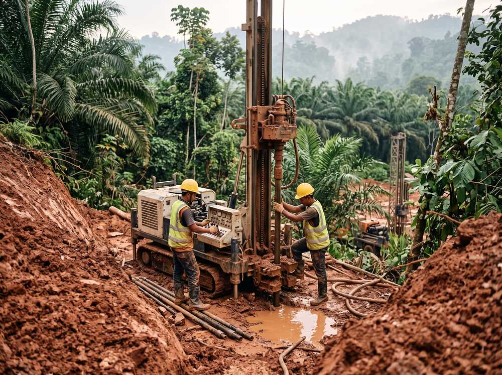
A drilling rig — usually truck-mounted or crawler-mounted for difficult terrain — is transported to site. For confined or hillside sites in Malaysia, smaller portable rigs may be used. The work area is secured and utilities are checked before drilling begins.
Step 3 — Drilling & Sampling
The borehole is advanced using rotary wash boring or percussion methods. As drilling progresses, the driller collects:
- Disturbed samples — using a split-spoon sampler during SPT, taken at every 1.5 m interval.
- Undisturbed samples — using thin-wall tube samplers (Shelby tubes) in cohesive soils for laboratory testing.
- Rock cores — using diamond core barrels when bedrock is encountered, with core recovery and Rock Quality Designation (RQD) recorded.
Step 4 — Standard Penetration Test (SPT)
The SPT is conducted at every sampling interval (typically every 1.5 m). A 63.5 kg hammer is dropped from a height of 760 mm to drive a split-spoon sampler 450 mm into the ground. The number of blows required for the last 300 mm of penetration is recorded as the N-value.
SPT N-value interpretation:
| SPT N-Value | Soil Condition (Granular Soil) | Soil Condition (Cohesive Soil) |
|---|---|---|
| 0–4 | Very loose | Very soft |
| 4–10 | Loose | Soft |
| 10–30 | Medium dense | Firm to stiff |
| 30–50 | Dense | Very stiff |
| >50 | Very dense | Hard |
Step 5 — In-Situ Testing
Depending on ground conditions, additional field tests may be conducted within or alongside the borehole:
- Field Vane Shear Test (FVST) — measures undrained shear strength of soft clay directly in the borehole.
- Permeability test (falling head / rising head) — measures how quickly water moves through the soil.
- Pressuremeter test — measures in-situ horizontal stress and deformation properties.
- Groundwater monitoring — water levels are recorded during and after drilling, and standpipe piezometers may be installed for long-term monitoring.
Step 6 — Laboratory Analysis
Soil samples collected during drilling are sent to an accredited laboratory. Common tests include:
- Moisture content and bulk density
- Atterberg Limits (Liquid Limit, Plastic Limit, Plasticity Index)
- Particle size distribution / sieve analysis
- Unconfined Compressive Strength (UCS) for rock cores
- Consolidation test (oedometer) for settlement prediction in clay
- Triaxial shear test for slope stability analysis
- Chemical tests (sulphate, chloride, pH, organic content)
Step 7 — Reporting & Interpretation
All data is compiled into a soil investigation report containing:
- Individual borehole logs with soil descriptions, SPT N-values and sample records
- Summary SPT profiles across the site
- Laboratory test certificates and results
- Soil stratigraphy sections showing how ground layers vary
- Groundwater level records
- Geotechnical recommendations for foundation design
Types of Borehole Drilling Methods Used in Malaysia
| Drilling Method | Description | Typical Use in Malaysia |
|---|---|---|
| Rotary wash boring | Uses a rotating bit with water/mud circulation to advance the hole | Most common method for soil and mixed ground conditions |
| Shell and auger (percussion) | Uses a weighted shell or auger to advance in soft to firm soils | Suitable for shallow boreholes in soft ground |
| Rotary coring | Uses a diamond-tipped core barrel to cut through rock | Used when bedrock (granite, limestone, sandstone) is encountered |
| Mackintosh Probe | Lightweight dynamic penetrometer driven by a drop hammer | Preliminary investigation in soft ground — quick and low-cost |
| Hand auger | Manual boring using a hand-operated auger | Shallow investigation (< 5 m) in accessible soft soils |
Malaysia-Specific Considerations for Borehole Testing
Tropical Weathering Profiles
Malaysia’s tropical climate produces deep weathering profiles where rock decomposes into residual soils that can extend 20–40 m or deeper. This means boreholes often need to penetrate through thick residual soil layers before reaching competent bedrock. The transition zone between soil and rock (Grade IV–V weathered rock) can be misleading — SPT N-values may appear high, but the material may not behave like intact rock.
Limestone & Karst Terrain
In limestone areas (Ipoh, Batu Caves, Perlis), borehole drilling can encounter sudden loss of drilling fluid when cavities are hit. Rock surfaces may be highly irregular — pinnacles and troughs — requiring closely spaced boreholes to map the bedrock profile. Supplementary geophysical methods like electrical resistivity surveys are often recommended.
Peat & Soft Clay Deposits
In peat and soft marine clay areas, boreholes may collapse without casing or drilling mud stabilisation. SPT N-values in very soft clay can be as low as 0–2, requiring alternative tests such as the Field Vane Shear Test for reliable strength measurement.
Ex-Mining & Reclaimed Land
Former tin mining areas contain highly variable fill — loose sand, gravel, clay pockets and occasionally buried timber or debris. Borehole spacing needs to be closer than normal to capture the variability. Similarly, reclaimed land requires assessment of both the fill material and the underlying natural ground.
Borehole Test vs Other Investigation Methods
| Method | What It Measures | Advantages | Limitations |
|---|---|---|---|
| Borehole Test (SPT) | Soil strength, stratigraphy, groundwater | Industry standard, provides physical samples, accepted by all regulators | Invasive, point-specific data, requires rig access |
| Cone Penetration Test (CPT) | Continuous soil resistance profile | Fast, continuous data, good for soft soils | No physical samples, limited in gravelly or rocky ground |
| Mackintosh Probe | Penetration resistance in soft soils | Very quick, low cost, minimal equipment | Shallow depth only, no samples, limited to soft ground |
| Electrical Resistivity Survey | Subsurface resistivity variations | Non-invasive, covers large areas, detects voids | Does not provide direct soil properties, needs borehole calibration |
| MASW Survey | Shear wave velocity profile | Non-invasive, maps soil stiffness, useful for seismic classification | Indirect measurement, requires borehole data for validation |
Borehole testing remains the most widely accepted method in Malaysia because it provides direct physical samples and measurable strength data. Other methods are best used as complementary techniques.
Cost Considerations for Borehole Testing in Malaysia

Borehole testing cost varies based on several factors:
- Mobilisation/demobilisation — a fixed charge for transporting the rig to site, typically higher for remote or hillside locations.
- Drilling rate — charged per metre of depth, with rates varying depending on soil type (drilling through rock costs more than soft soil).
- SPT testing — usually included in the drilling rate but may be itemised separately.
- Sampling — undisturbed samples (Shelby tube) cost more than disturbed samples.
- Laboratory testing — each test is priced individually; more tests add to the overall cost.
- Standpipe piezometer installation — if groundwater monitoring is required.
- Supervision & reporting — professional geological or geotechnical supervision and report preparation.
For indicative cost ranges by project type, refer to the soil investigation cost guide published on our site. Actual pricing depends on project-specific scope — always request a detailed quotation from a qualified geotechnical consultant.
Common Mistakes in Borehole Testing
1. Insufficient borehole depth — Terminating boreholes before reaching competent ground. The borehole should penetrate deep enough to confirm the founding stratum for the proposed foundation.
2. Too few boreholes — Relying on one or two boreholes for a large site misses ground variability. Malaysian ground conditions can change dramatically over short distances, especially in karst and ex-mining areas.
3. Poor sample handling — Disturbing “undisturbed” samples during transport to the laboratory. Improperly sealed or handled samples produce unreliable lab results.
4. Ignoring groundwater — Failing to record water levels accurately or not installing piezometers when long-term monitoring is needed.
5. No qualified supervision — Borehole drilling without on-site supervision by a geologist or geotechnical engineer. The driller operates the rig, but a qualified professional is needed to log the borehole, classify soils and make real-time decisions about testing.
Practical Checklist for Commissioning Borehole Tests
- Project site plan with proposed building layout and loading information available
- Number and location of boreholes discussed with geotechnical consultant
- Required borehole depth confirmed based on expected foundation type
- Scope includes SPT at standard intervals (every 1.5 m)
- Undisturbed sampling specified for clay layers requiring consolidation testing
- Rock coring specified if bedrock is expected within the investigation depth
- Laboratory testing programme agreed — not just SPT data
- Groundwater monitoring requirements confirmed
- Drilling contractor has appropriate rig for site conditions (access, terrain)
- Qualified geologist or geotechnical engineer assigned for field supervision
- Report deliverables and timeline agreed in writing
FAQ
1. What is a borehole test and how is it done?
A borehole test involves drilling a narrow hole into the ground to collect soil and rock samples at regular depth intervals. During drilling, the Standard Penetration Test (SPT) is performed to measure soil resistance. Additional field tests and laboratory analysis may be conducted depending on the project scope. The data is compiled into a borehole log and geotechnical report.
2. Who needs borehole testing?
Any party involved in construction — developers, structural engineers, geotechnical consultants, architects and contractors — needs borehole test data to design safe foundations. In Malaysia, local authorities typically require borehole test reports as part of development plan submissions, particularly for multi-storey buildings, slopes and infrastructure projects.
3. Can borehole testing detect underground voids or cavities?
Borehole testing can detect voids when the drill encounters sudden drops or loss of drilling fluid, particularly in limestone/karst terrain. However, boreholes only provide point-specific data. To map the extent of underground voids across a site, geophysical methods such as electrical resistivity surveys are recommended as complementary investigations.
4. How deep should a borehole be drilled?
Borehole depth depends on the proposed structure and expected ground conditions. As a general guideline, boreholes should penetrate at least 1.5 to 2 times the width of the proposed foundation below the founding level, or extend into competent bedrock. For piled foundations, boreholes should reach at least 5 m below the anticipated pile toe level.
5. Is the SPT N-value the only thing that matters in a borehole test?
No. While the SPT N-value is the most commonly referenced parameter, a comprehensive borehole test also provides soil classification, moisture content, Atterberg limits, shear strength data, consolidation properties and groundwater information. Relying on SPT N-values alone — without supporting laboratory data — can lead to incomplete or inaccurate geotechnical assessments.
Why Choose Geotechnica?
Geotechnica Sdn Bhd brings over 15 years of borehole testing and geotechnical investigation experience across Malaysia’s diverse ground conditions.
- Experienced drilling teams — equipped with rotary and percussion rigs suitable for soft ground, mixed soils and rock, including challenging hillside and remote sites.
- Qualified field supervision — every borehole programme is supervised by registered geologists under the leadership of P.Geol. Gs. Hairil Azwan Razak.
- Integrated investigation approach — borehole testing combined with geophysical surveys (electrical resistivity, MASW) and LiDAR mapping for comprehensive ground assessment.
- Accredited laboratory partnerships — all samples tested at accredited facilities to Malaysian and international standards.
- End-to-end service — from investigation planning to final geotechnical reporting and foundation recommendations.
Conclusion
A borehole test is the most fundamental and widely accepted method for understanding ground conditions in Malaysia. It provides direct physical evidence of what lies beneath the surface — soil types, strength, groundwater and potential hazards — that no other investigation method can fully replace.
For engineers, the borehole log is not just data — it is the foundation of every foundation design decision. Commissioning borehole tests from a qualified geotechnical consultant, with adequate scope and proper supervision, is the most effective way to reduce construction risk and avoid costly ground-related surprises.
SOURCES / REFERENCES
- BS 5930:2015+A1:2020 — Code of Practice for Ground Investigations
- BS EN ISO 22476-3 — Standard Penetration Test (SPT)
- BS EN ISO 22475-1 — Sampling by Drilling and Excavation Methods
- Jabatan Kerja Raya (JKR) Malaysia — Geotechnical Investigation Guidelines
- Jabatan Mineral dan Geosains Malaysia (JMG) — Geological Survey Data
- Institution of Engineers Malaysia (IEM) — Geotechnical Engineering Division
- Geotechnica Sdn. Bhd. — internal project data and technical references
This article has been technically reviewed by P.Geol. Gs. Hairil Azwan, Geohazard Specialist and Managing Director at Geotechnica Sdn. Bhd., with 15 years of professional experience in geology, geotechnical engineering and geospatial technology.
Next Review: 10 February 2027


